Official Discussion issued by the National Hurricane Center
Joyce (AL102018) DATA RELEASED: 9/18/2018 5:00:00 AM UTC
|
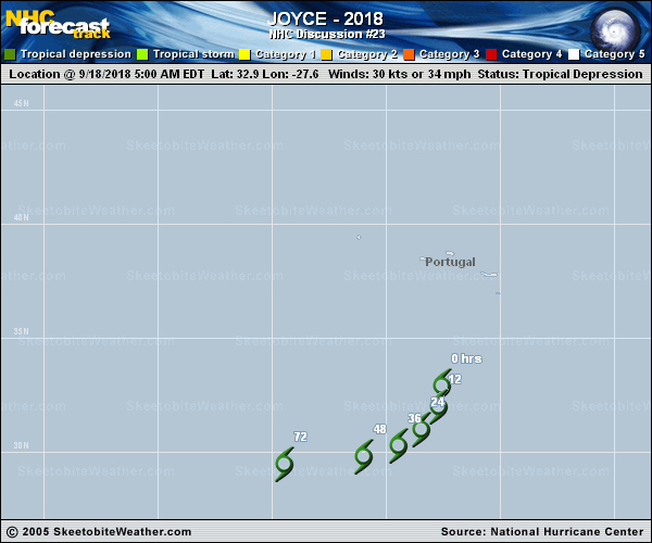
Copy of official data Tropical Depression Joyce Discussion Number 23 NWS National Hurricane Center Miami FL AL102018 500 AM AST Tue Sep 18 2018 The latest convective burst associated with Joyce is weakening due to the effects of 35-40 kt of westerly vertical shear and very dry mid-level air. Satellite intensity estimates have changed little since the previous advisory, so the initial intensity remains 30 kt. The cyclone is expected to gradually weaken due to the ongoing shear and dry air entrainment, and the new intensity forecast again calls for the system to become a remnant low in 12-24 h. Dissipation of the remnants is forecast in 72-96 h in agreement with the global model guidance. As indicated in the previous discussion, there is an alternative scenario where interaction with an upper-level trough seen in water vapor imagery to the northwest of Joyce maintains organized convection longer than currently forecast. The initial motion is now 165/5. Joyce is forecast to move around the eastern periphery of a deep-layer ridge located across the eastern Atlantic, with the cyclone or its remnants turning southwestward during the next 36 h and westward by 72 h. The new forecast track generally lies between the TVCA and HCCA consensus models. FORECAST POSITIONS AND MAX WINDS INIT 18/0900Z 32.9N 27.6W 30 KT 35 MPH 12H 18/1800Z 32.0N 27.7W 30 KT 35 MPH 24H 19/0600Z 31.0N 28.5W 25 KT 30 MPH...POST-TROP/REMNT LOW 36H 19/1800Z 30.3N 29.5W 25 KT 30 MPH...POST-TROP/REMNT LOW 48H 20/0600Z 29.8N 31.0W 25 KT 30 MPH...POST-TROP/REMNT LOW 72H 21/0600Z 29.5N 34.5W 20 KT 25 MPH...POST-TROP/REMNT LOW 96H 22/0600Z...DISSIPATED $$ Forecaster Beven |