Official Discussion issued by the National Hurricane Center
Joyce (AL102018) DATA RELEASED: 9/17/2018 11:00:00 PM UTC
|
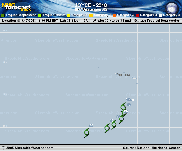
Copy of official data Tropical Depression Joyce Discussion Number 22 NWS National Hurricane Center Miami FL AL102018 1100 PM AST Mon Sep 17 2018 Joyce remains a very resilient tropical cyclone. After an earlier burst of deep convection just east of the low-level center that has since dissipated, a new convective burst has developed just north of the center with a curved convective band trying to develop in the eastern semicircle. All of this convective activity has been occurring despite westerly 850-200-mb vertical wind shear of near 35 kt and in the presence of very dry mid-level air. The initial intensity is being maintained a 30 kt based on earlier 28-kt ASCAT wind data, and the fact that no significant change has occurred to Joyce's low-level appearance in satellite imagery. The initial motion estimate is now 155/06 kt. Joyce is forecast to move around the eastern periphery of a deep-layer ridge located across the eastern Atlantic to the southwest and west of the cyclone. This large-scale steering feature is expected to gradually turn Joyce toward the south overnight and on Tuesday, and then force the cyclone toward the southwest on Wednesday and Thursday. The new NHC track forecast is to the west of the previous advisory track, and lies near the middle of the guidance envelope close to a blend of the consensus models TVCA and HCCA. Convective development during the past 12 hours has been in large part due to the strong atmospheric instability created by very cold 200-mb temperatures near -57 deg C overlaying relatively warm ocean temperatures of 25.5 deg C. A contributing factor to the most recent convective development appears to be enhanced uplift caused by an approaching shortwave trough noted in water vapor imagery between 30W-35W longitude. The latter feature is forecast by most of the global models to cut off south of the Azores and become entangled with Joyce's circulation over the next few days, resulting in a sharp decrease in the vertical wind shear and an increase in atmospheric instability/CAPE by 48 h and beyond, which would aid convective development and re-strengthening. For now, however, the new intensity forecast continues the weakening trend of the previous advisories due to an abundance of very dry mid-level air being entrained into the circulation, which is expected to shut down convective development, causing Joyce to dissipate shortly after 72 h. However, confidence in this forecast scenario is not very high, and some adjustments may be required to subsequent forecasts once the 18/0000Z model guidance becomes available, especially since the GFS- and ECMWF-based SHIPS and LGEM intensity guidance maintains Joyce as a 30- to 35-kt tropical cyclone through the next 120 hours. FORECAST POSITIONS AND MAX WINDS INIT 18/0300Z 33.2N 27.3W 30 KT 35 MPH 12H 18/1200Z 32.4N 27.1W 30 KT 35 MPH 24H 19/0000Z 31.4N 27.6W 25 KT 30 MPH...POST-TROP/REMNT LOW 36H 19/1200Z 30.5N 28.7W 25 KT 30 MPH...POST-TROP/REMNT LOW 48H 20/0000Z 29.9N 29.8W 25 KT 30 MPH...POST-TROP/REMNT LOW 72H 21/0000Z 29.2N 33.0W 20 KT 25 MPH...POST-TROP/REMNT LOW 96H 22/0000Z...DISSIPATED $$ Forecaster Stewart |