Official Discussion issued by the National Hurricane Center
Isaac (AL092018) DATA RELEASED: 9/14/2018 11:00:00 AM UTC
|
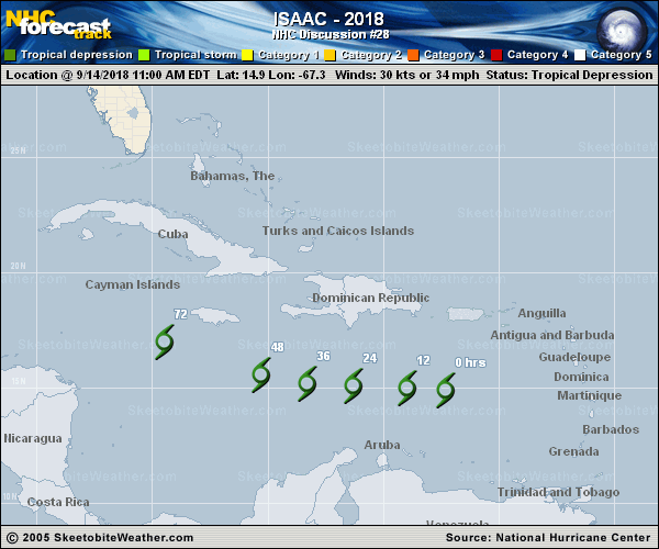
Copy of official data Tropical Depression Isaac Discussion Number 28 NWS National Hurricane Center Miami FL AL092018 1100 AM AST Fri Sep 14 2018 Deep convection has been increasing near the center of Isaac, but visible imagery indicates that the circulation has become more elongated from northeast to southwest. It is possible that Isaac is in the process of losing a well-defined center, but we will know more about the wind structure in a few hours since the NOAA Hurricane Hunter aircraft should be in the area. The initial wind speed is held at 30 kt. Vertical shear has decreased near Isaac, with some outflow in the western semicircle noted and consolidation of the convection. Still, this area of the eastern Caribbean isn't known as the graveyard for nothing, and the system might just be too shallow and disorganized to take advantage of the changing environment. Almost all of the dynamical models, save the UKMET, show the cyclone moving westward to west-northwestward at a slower forward speed during the next few days and degenerating into an open wave in the central Caribbean Sea. This solution is also supported by fewer members of the GFS and ECMWF ensemble now maintaining a coherent system in the long range. Little change is made to the previous track and intensity forecasts, and we will see what the aircraft finds this afternoon and if the 1200 UTC model cycle maintains the dissipation trend. FORECAST POSITIONS AND MAX WINDS INIT 14/1500Z 14.9N 67.3W 30 KT 35 MPH 12H 15/0000Z 15.0N 69.0W 30 KT 35 MPH 24H 15/1200Z 15.1N 71.3W 30 KT 35 MPH 36H 16/0000Z 15.2N 73.3W 25 KT 30 MPH 48H 16/1200Z 15.6N 75.3W 25 KT 30 MPH 72H 17/1200Z 17.0N 79.5W 25 KT 30 MPH 96H 18/1200Z...DISSIPATED $$ Forecaster Blake |