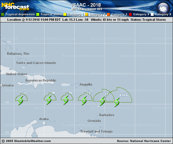
Official Discussion issued by the National Hurricane Center
Isaac (AL092018) DATA RELEASED: 9/12/2018 11:00:00 PM UTC
|
Copy of official data Tropical Storm Isaac Discussion Number 22 NWS National Hurricane Center Miami FL AL092018 1100 PM AST Wed Sep 12 2018 A NOAA P-3 Hurricane Hunter plane has been investigating Isaac this evening, and the data show that the cyclone has weakened a bit. The maximum 850-mb flight-level wind measured by the plane was 47 kt, and the highest SFMR winds not coincident with a rain spike were around 45 kt. Based on these wind data, the initial intensity is lowered to 45 kt, and the minimum pressure is up to 1006 mb based on dropsonde data. Additionally, a superposition of the flight-level wind and dropsonde surface wind data suggest that Isaac may not have a closed circulation at 850 mb but is still hanging on to one at the surface. All of Isaac's deep convection is displaced 60-120 n mi to the northeast and southeast of the low-level center due to around 30 kt of westerly shear. This magnitude of the shear is not expected to decrease during the next 12-24 hours, so at the very least, gradual weakening is anticipated. With the circulation so fragile and limited to below 850 mb, however, it's entirely possible that Isaac could open up into a wave at any time. Even if degeneration into a wave occurs, the system would likely carry tropical-storm-force winds across the Leeward Islands on Thursday. After Isaac moves into the eastern Caribbean Sea, there is a lot of uncertainty regarding its future. The 18Z GFS has come back in line with the ECMWF, showing Isaac opening up into a trough over the central and western Caribbean Sea, but the environmental conditions (lower shear, warm sea surface temperatures, etc.) would suggest that the system would have an opportunity to restrengthen. For now, the new NHC intensity forecast maintains continuity from the previous advisory, showing gradual weakening through 48 hours and then holding the system at 35 kt through day 5. This remains a low confidence forecast until we know if Isaac survives the next couple of days. Isaac continues to move quickly westward with an initial motion of 270/17 kt. The track guidance remains tightly clustered on a nearly due westward motion for much of the forecast period, with some of the same speed differences noted in previous forecasts. Especially since Isaac's speed has been faster than forecast, the NHC track forecast continues to favor the faster guidance, in particular the ECMWF, GFS, and HCCA models. Reconnaissance and scatterometer data suggest that there are no tropical-storm-force winds within the southern semicircle, but the radii we've been carrying within the northern semicircle appear reasonable. The wind radii forecast have been adjusted to account for the new initial radii. Key Messages: 1. Isaac is expected to still be producing tropical-storm-force winds when it moves across the Lesser Antilles on Thursday, and tropical storm warnings are in effect for Martinique, Dominica, and Guadeloupe. Tropical storm watches are in effect for Montserrat, St. Kitts and Nevis, Antigua, Saba and St. Eustatius, St. Maarten, and St. Martin. Interests on those islands should follow any advice given by their local officials. 2. Life-threatening flash flooding is possible with Isaac. The storm is expected to produce total rainfall accumulations of 2 to 4 inches with isolated amounts up 8 inches across Martinique, Dominica and Guadeloupe. Rainfall amounts of 1 to 2 inches with isolated amounts to 4 inches are expected across Puerto Rico and the southern United States Virgin Islands. FORECAST POSITIONS AND MAX WINDS INIT 13/0300Z 15.3N 58.0W 45 KT 50 MPH 12H 13/1200Z 15.5N 60.4W 45 KT 50 MPH 24H 14/0000Z 15.6N 63.4W 40 KT 45 MPH 36H 14/1200Z 15.7N 66.4W 40 KT 45 MPH 48H 15/0000Z 15.7N 69.2W 35 KT 40 MPH 72H 16/0000Z 15.6N 73.9W 35 KT 40 MPH 96H 17/0000Z 16.5N 77.5W 35 KT 40 MPH 120H 18/0000Z 17.5N 82.0W 35 KT 40 MPH $$ Forecaster Berg |