Official Discussion issued by the National Hurricane Center
Isaac (AL092018) DATA RELEASED: 9/10/2018 5:00:00 AM UTC
|
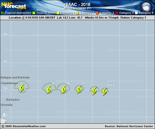
Copy of official data Hurricane Isaac Discussion Number 11 NWS National Hurricane Center Miami FL AL092018 500 AM AST Mon Sep 10 2018 Isaac has generally changed little during the past several hours. The small hurricane continues to have a central dense overcast feature with some fragmented bands to the south of the center. The Dvorak classifications remain 4.0/65 kt from both TAFB and SAB, and therefore, the initial intensity is held at 65 kt. Isaac is moving westward at 11 kt. The models remain in poor agreement this cycle as they are split into two camps. The UKMET, HWRF, and a few other models show Isaac recurving near or to the east of the Lesser Antilles toward a developing trough over the central Atlantic. Conversely, the GFS and ECMWF have been very consistent in showing a due westward motion across the Lesser Antilles and into the Caribbean as the cyclone moves on the south side of a strengthening mid-level ridge. The NHC track forecast continues to favor the usually more reliable GFS and ECMWF models, and this forecast is near a blend of those aids. It should be noted, however, that confidence in this track forecast is low given the model spread. The intensity forecast is also quite uncertain. One of the complex factors is Isaac's compact size as small hurricanes like this one are more prone to quick intensity changes, both up and down. In addition, the intensity guidance is in poor agreement as solutions range from steady weakening from this point onward to the HWRF that shows Isaac becoming a major hurricane. Given that the wind shear is expected to remain less than 10 kt for another day or two, strengthening is forecast during that time period. After that, however, an increase in shear first from a trough over the central Atlantic and later from the outflow from Florence should result in weakening when the system moves across the Lesser Antilles and into the Caribbean Sea. The NHC intensity forecast is not too different from the previous one and lies above the model consensus in the short term, but below it at the later forecast times. This forecast is in best agreement with the latest LGEM guidance. Key Messages: 1. Isaac is a small hurricane and uncertainty in the forecast is higher than normal. Although Isaac is forecast to begin weakening when it approaches the Lesser Antilles, it is still expected to be at or near hurricane intensity when it reaches the islands. 2. Interests in the Lesser Antilles should continue to monitor Isaac during the next few days. FORECAST POSITIONS AND MAX WINDS INIT 10/0900Z 14.7N 42.7W 65 KT 75 MPH 12H 10/1800Z 14.8N 44.6W 75 KT 85 MPH 24H 11/0600Z 15.0N 47.4W 75 KT 85 MPH 36H 11/1800Z 15.0N 50.3W 80 KT 90 MPH 48H 12/0600Z 15.0N 53.0W 75 KT 85 MPH 72H 13/0600Z 15.3N 58.0W 65 KT 75 MPH 96H 14/0600Z 15.5N 64.0W 50 KT 60 MPH 120H 15/0600Z 15.6N 69.2W 40 KT 45 MPH $$ Forecaster Cangialosi |