Official Discussion issued by the National Hurricane Center
Helene (AL082018) DATA RELEASED: 9/15/2018 5:00:00 PM UTC
|
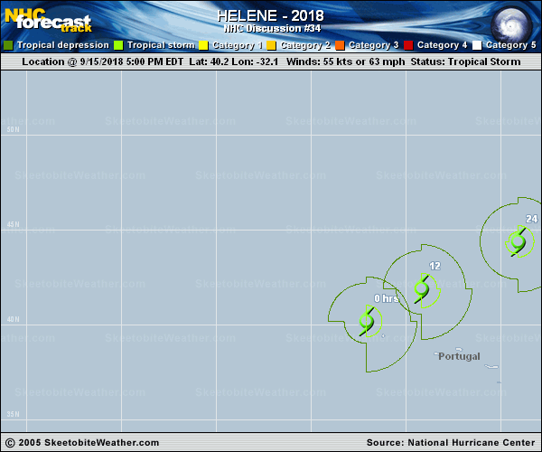
Copy of official data Tropical Storm Helene Discussion Number 34 NWS National Hurricane Center Miami FL AL082018 500 PM AST Sat Sep 15 2018 The cloud pattern of Helene is gradually decaying and transitioning to a shear pattern, with the low-level center occasionally visible through breaks in the cirrus overcast. The initial intensity is reduced to 55 kt in best agreement with the CIMSS satellite consensus. Helene is moving toward colder water and into increasing shear associated with the mid-latitude westerlies. This should cause continued weakening and, as Helene merges with a frontal system, extratropical transition in about 36 h. The forecast will continue to call for Helene or its remnants to be absorbed into a large non-tropical low over the North Atlantic between 72-96 h, and the latest global model guidance suggests this could happen earlier than forecast. The initial motion is now 050/19. A mostly northeastward motion at a faster forward speed should occur during the remainder of the cyclone's life as it becomes more embedded in the westerlies. On the forecast track, Helene should pass near or over the western Azores during the next several hours, and head toward Ireland and the United Kingdom Sunday night and Monday. There are again no significant changes to either the track guidance or the official forecast track since the last advisory. Tropical storm conditions are spreading over portions of the Azores and should continue through tonight. Helene is also expected to be a storm-force post-tropical cyclone when it approaches Ireland and the United Kingdom in two to three days. Interests in those locations should consult products from their local meteorological service for information about potential impacts from Helene. Local forecasts and warnings for the UK can be found on the website of the UK Met Office at https://www.metoffice.gov.uk/. Local forecasts and warnings for Ireland can be found on the website of Met Eireann at https://www.met.ie/. FORECAST POSITIONS AND MAX WINDS INIT 15/2100Z 40.2N 32.1W 55 KT 65 MPH 12H 16/0600Z 41.9N 29.2W 55 KT 65 MPH 24H 16/1800Z 44.4N 24.1W 55 KT 65 MPH 36H 17/0600Z 47.2N 17.9W 55 KT 65 MPH...POST-TROP/EXTRATROP 48H 17/1800Z 51.2N 11.1W 50 KT 60 MPH...POST-TROP/EXTRATROP 72H 18/1800Z 61.0N 1.0E 50 KT 60 MPH...POST-TROP/EXTRATROP 96H 19/1800Z...ABSORBED BY EXTRATROPICAL LOW $$ Forecaster Beven |