Official Discussion issued by the National Hurricane Center
Helene (AL082018) DATA RELEASED: 9/13/2018 5:00:00 PM UTC
|
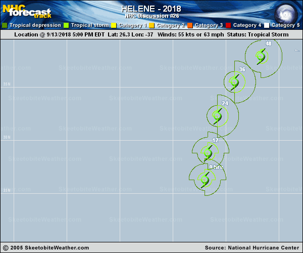
Copy of official data Tropical Storm Helene Discussion Number 26 NWS National Hurricane Center Miami FL AL082018 500 PM AST Thu Sep 13 2018 Helene has maintained deep convection this afternoon though only in the northern semicircle. Dvorak estimates from TAFB and SAB are continuing to drop, and a blend of these with the CIMSS SATCON supports lowering the intensity to 55 kt. Strong tropospheric vertical shear along with only lukewarm waters are likely contributing toward Helene's weakening. The shear should further increase during the next two days, though the sea surface temperatures will rebound up to 27C along with an increase in low-level moisture. Helene is expected to be either slowly weakening or steady state during this time. Beginning in about three days, Helene will commence baroclinic transition, and it is expected to become an extratropical cyclone by 96 hours. The baroclinic forcing should preclude any additional weakening through the remainder of the forecast period, and the official intensity forecast is nearly the same as the last advisory. This prediction is based on a blend of the stronger HWRF/COAMPS dynamical models and the weaker SHIPS/LGEM statistical schemes for the next couple of days, and is based on a blend of the GFS/ECMWF/UKMET global models at the extended lead times. Helene is moving northward at about 12 kt between the subtropical ridge to its east and a deep-layer trough to its west. The system should accelerate and turn toward the northeast over the next few days as it rounds the subtropical ridge and starts getting picked up by the mid-latitude westerlies. The official track forecast is based upon the tightly clustered variable consensus technique (TVCN) and is nearly the same as the previous forecast. FORECAST POSITIONS AND MAX WINDS INIT 13/2100Z 26.3N 37.0W 55 KT 65 MPH 12H 14/0600Z 28.8N 36.7W 50 KT 60 MPH 24H 14/1800Z 32.3N 35.8W 50 KT 60 MPH 36H 15/0600Z 35.5N 34.2W 50 KT 60 MPH 48H 15/1800Z 37.9N 31.7W 50 KT 60 MPH 72H 16/1800Z 40.6N 24.4W 50 KT 60 MPH 96H 17/1800Z 44.0N 17.5W 50 KT 60 MPH...POST-TROP/EXTRATROP 120H 18/1800Z 51.0N 7.5W 50 KT 60 MPH...POST-TROP/EXTRATROP $$ Forecaster Landsea |