Official Discussion issued by the National Hurricane Center
Helene (AL082018) DATA RELEASED: 9/10/2018 11:00:00 PM UTC
|
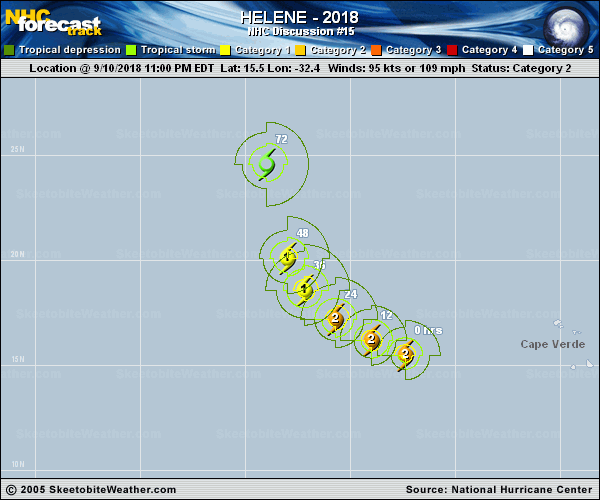
Copy of official data Hurricane Helene Discussion Number 15 NWS National Hurricane Center Miami FL AL082018 1100 PM AST Mon Sep 10 2018 Helene remains a well organized hurricane with a fairly large 25 n mi diameter eye and ring of cold cloud tops surrounding that feature. There are a few dry slots beyond the inner core, however, which have prevented some of the Dvorak estimates from increasing this cycle. A blend of the latest subjective and objective satellite intensity estimates supports raising the initial intensity slightly to 95 kt. The hurricane has a limited amount of time to strengthen as the current environment of low wind shear and relatively warm SSTs will be changing soon. Helene is expected to cross the 26 deg C isotherm within 24 hours and it will enter an environment of increasing south-southwesterly shear just beyond that time period. These conditions should promote a steady weakening trend beginning late Tuesday. By the end of the forecast period, however, SSTs increase along the forecast track, and there could be some baroclinic enhancements to end the weakening trend and perhaps even cause some strengthening. This scenario is supported by the HWRF/HMON regional models and the GFS/ECMWF global models. The NHC intensity forecast is largely an update of the previous one, except it is slightly higher at the end of the period. The hurricane is gradually turning to the right, with the latest initial motion estimate being 295/13 kt. A large mid- to upper-level trough over the north Atlantic is expected to dig southward causing a significant weakness in the subtropical ridge. In response to this change in the steering pattern, Helene is forecast to gradually turn northward and then north-northeastward during the next several days. The track models are in fairly good agreement, and the NHC track forecast lies near the middle of the guidance envelope. This forecast is only a little to the right of the previous track. FORECAST POSITIONS AND MAX WINDS INIT 11/0300Z 15.5N 32.4W 95 KT 110 MPH 12H 11/1200Z 16.2N 34.0W 95 KT 110 MPH 24H 12/0000Z 17.2N 35.7W 85 KT 100 MPH 36H 12/1200Z 18.6N 37.2W 75 KT 85 MPH 48H 13/0000Z 20.1N 38.0W 65 KT 75 MPH 72H 14/0000Z 24.6N 39.0W 60 KT 70 MPH 96H 15/0000Z 30.0N 38.0W 50 KT 60 MPH 120H 16/0000Z 36.2N 34.0W 55 KT 65 MPH $$ Forecaster Cangialosi |