Official Discussion issued by the National Hurricane Center
Helene (AL082018) DATA RELEASED: 9/10/2018 5:00:00 PM UTC
|
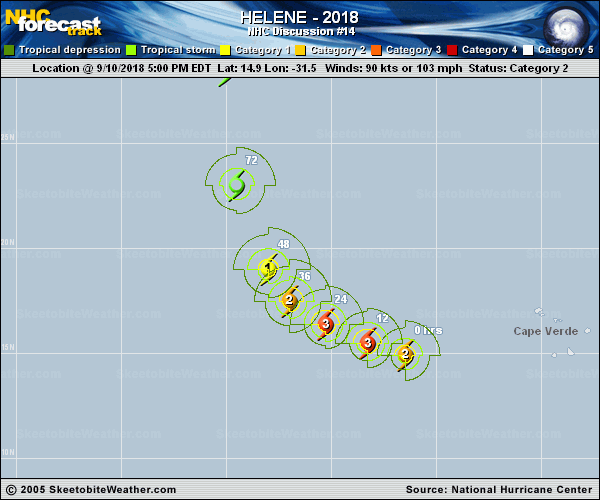
Copy of official data Hurricane Helene Discussion Number 14 NWS National Hurricane Center Miami FL AL082018 500 PM AST Mon Sep 10 2018 Helene's cloud pattern continues to be well organized with a large eye of about 20 nm in diameter, surrounded by a ring of deep convection. The cyclone's circulation is large with numerous cyclonically curved convective bands, and the outflow is fair in all quadrants. Dvorak classifications have not changed much, and support an initial intensity of 90 kt. Helene has the opportunity to strengthen some during the next 24 hours or so, while the shear is low and the ocean is still relatively warm. After that time, both shear and SSTs will become less favorable and gradual weakening should then begin. The NHC intensity forecast is similar to the previous one, and follows closely the intensity consensus aids. Helene is moving toward the west-northwest or 290 degrees at 15 kt. Soon, the hurricane will encounter a mid-level trough which the most reliable global models are forming in the eastern Atlantic. This new flow pattern will force Helene to turn to the northwest and north ahead of the developing trough. Track models are quite consistent with this solution and the the spread of the guidance envelope is small through the forecast period. This increases the confidence in the Helene's northward turn, followed by recurvature over the eastern Atlantic. FORECAST POSITIONS AND MAX WINDS INIT 10/2100Z 14.9N 31.5W 90 KT 105 MPH 12H 11/0600Z 15.5N 33.3W 100 KT 115 MPH 24H 11/1800Z 16.4N 35.3W 100 KT 115 MPH 36H 12/0600Z 17.5N 37.0W 85 KT 100 MPH 48H 12/1800Z 19.0N 38.0W 75 KT 85 MPH 72H 13/1800Z 23.0N 39.5W 60 KT 70 MPH 96H 14/1800Z 28.5N 40.0W 50 KT 60 MPH 120H 15/1800Z 34.0N 37.0W 50 KT 60 MPH $$ Forecaster Avila |