Official Discussion issued by the National Hurricane Center
Helene (AL082018) DATA RELEASED: 9/10/2018 5:00:00 AM UTC
|
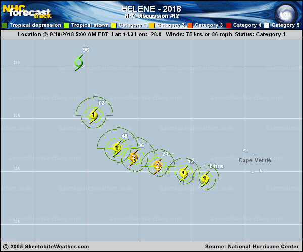
Copy of official data Hurricane Helene Discussion Number 12 NWS National Hurricane Center Miami FL AL082018 500 AM AST Mon Sep 10 2018 Little change in the Helene's cloud pattern has been observed during the past 6 hours. The earlier mentioned ragged banding-type eye feature is still apparent in the enhanced infrared BD-curve imagery and a recent SSMI/S microwave overpass. The initial intensity is held at 75 kt, and is based on the subjective Dvorak intensity estimates. Helene is moving within a fairly ripe environment and over warm oceanic sea surface temperatures. These conducive conditions should promote additional strengthening over the next 36 hours. Afterward, increasing south-southwesterly shear, lower mid-tropospheric moisture, and cooler water are expected to induce weakening, however gradually, through day 5. The official forecast follows suit and is similar to the better performing IVCN intensity consensus model. Helene's initial motion is estimated to be west-northwestward, or 285/15 kt, and this general motion is forecast during the next 48 hours. Beyond that period, a break in the subtropical ridge to the northwest of Paul, created by a mid- to upper-level cut-off low digging southward, should induce a northward turn with a gradual increase in forward motion. The large-scale models all indicate this change in the synoptic steering pattern, although there is some disparity on how soon Helene will turn toward the north. The NHC track is quite close to the previous forecast and lies between the consensus guidance. FORECAST POSITIONS AND MAX WINDS INIT 10/0900Z 14.3N 28.9W 75 KT 85 MPH 12H 10/1800Z 14.8N 30.9W 80 KT 90 MPH 24H 11/0600Z 15.5N 33.4W 85 KT 100 MPH 36H 11/1800Z 16.3N 35.6W 85 KT 100 MPH 48H 12/0600Z 17.2N 37.2W 80 KT 90 MPH 72H 13/0600Z 20.3N 39.4W 65 KT 75 MPH 96H 14/0600Z 25.3N 40.8W 55 KT 65 MPH 120H 15/0600Z 31.2N 41.1W 50 KT 60 MPH $$ Forecaster Roberts |