Official Discussion issued by the National Hurricane Center
Franklin (AL072017) DATA RELEASED: 8/7/2017 10:00:00 AM UTC
|
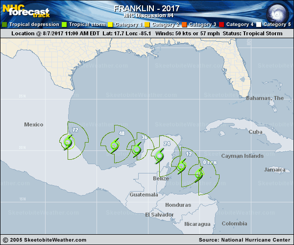
Copy of official data Tropical Storm Franklin Discussion Number 4 NWS National Hurricane Center Miami FL AL072017 1000 AM CDT Mon Aug 07 2017 Visible and microwave satellite imagery shows that Franklin's cloud pattern is becoming better organized with banding features starting to appear. Inner-core convection is not very abundant over the southwest quadrant and the center is still estimated to be located near the southwest edge of the main cloud mass. Given the increase in organization after the 12Z Dvorak intensity estimate of 45 kt from TAFB, the advisory intensity is set to 50 kt. An Air Force Hurricane Hunter aircraft is scheduled to investigate Franklin this afternoon and should provide a better estimate of the strength of the storm. The upper-level environment is becoming increasingly conducive for intensification, with anticyclonic outflow becoming established over the tropical cyclone during the next couple of days. Franklin could become a hurricane before its first landfall, but interaction with the Yucatan Peninsula will cause some weakening on Tuesday. Thereafter, Franklin will be moving over SSTs near 30 deg C, which of course favors strengthening. A complicating factor at days 2 and 3 could be some northerly shear associated with an upper-level ridge over northeastern Mexico, as indicated by the global models. Nonetheless Franklin should be near or at hurricane intensity by the time it makes landfall in mainland Mexico. The official intensity forecast is a little above the model consensus. The initial motion continues to be west-northwestward or 300/12 kt. Little changes have been made to the track forecast from previous advisories. The steering environment remains fairly simple, and is dominated by a zonally-oriented ridge that should cause a west-northwestward to westward motion for the next several days. The official track forecast is close to the dynamical model consensus TVCN and leans slightly toward the ECMWF at the end of the period. FORECAST POSITIONS AND MAX WINDS INIT 07/1500Z 17.7N 85.1W 50 KT 60 MPH 12H 08/0000Z 18.5N 86.8W 60 KT 70 MPH 24H 08/1200Z 19.5N 88.9W 40 KT 45 MPH...INLAND 36H 09/0000Z 20.1N 91.1W 45 KT 50 MPH...OVER WATER 48H 09/1200Z 20.5N 93.3W 60 KT 70 MPH...OVER WATER 72H 10/1200Z 20.8N 97.8W 60 KT 70 MPH...INLAND 96H 11/1200Z...DISSIPATED $$ Forecaster Pasch |