Official Discussion issued by the National Hurricane Center
Florence (AL062018) DATA RELEASED: 9/9/2018 5:00:00 AM UTC
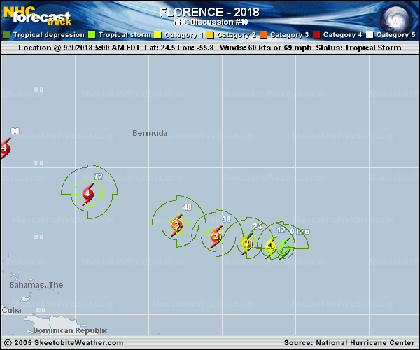
|
Copy of official data Tropical Storm Florence Discussion Number 40 NWS National Hurricane Center Miami FL AL062018 500 AM AST Sun Sep 09 2018 Florence's cloud pattern has continued to gradually become better organized overnight, with an increase in convection near the center and a developing central dense overcast feature. However, the cloud tops are not particularly cold and the outer banding features remain fragmented likely due to some nearby dry mid-level air. Dvorak intensity estimates from TAFB and SAB range from 55 to 65 kt, so the initial intensity remains 60 kt, just shy of hurricane strength. The NOAA Hurricane Hunters are scheduled to investigate the storm later today, and that data should provide a better assessment of Florence's intensity. The upper-level outflow is becoming well established over the cyclone, and the global model guidance indicates that Florence will remain in a very favorable upper-level environment while the cyclone moves over the warm waters over the southwestern Atlantic. These conditions favor strengthening with the only apparent negative factor being nearby dry air, which will likely remain away from the inner core due to the low shear conditions. The NHC intensity forecast again calls for a period of rapid strengthening within the next 12-36 hours, and Florence is forecast to become a major hurricane on Monday with additional strengthening early in the week. This means that Florence is likely to be a very powerful hurricane as it moves over the western Atlantic toward the southeastern United States. The new NHC intensity forecast is near the various intensity consensus aids and is very similar to the previous official forecast. Florence is currently located between a couple of mid-level ridges and a slow westward motion is expected today. Another strong high pressure ridge is forecast to build to the north of Florence on Monday, which should cause the storm to begin moving west-northwestward to northwestward at an increasingly faster forward speed. The dynamical model guidance is tightly clustered for the first 2-3 days with increasing spread thereafter. The GFS remains along the right side of the guidance envelope with the HWRF and ECMWF bracketing the left edge. It should be noted that both the GFS and ECMWF ensemble means are a little to the left or west of their operational runs. As a result, the NHC track forecast lies to the left of the TVCA multi-model consensus, but is not as far to the west as the FSSE and HCCA corrected consensus models at day 5. The models are in agreement that Florence is likely to slow down near the end of the forecast period as a blocking high pressure ridge builds to the north of the hurricane. Key Messages: 1. Florence is forecast to be a dangerous major hurricane near the southeast U.S. coast by late this week, and the risk of direct impacts continues to increase. However, given the uncertainty in track and intensity forecasts at those time ranges, it's too soon to determine the exact timing, location, and magnitude of those impacts. 2. Interests along the U.S. East Coast, particularly from north Florida through North Carolina, should closely monitor the progress of Florence, ensure they have their hurricane plan in place, and follow any advice given by local officials. 3. Large swells affecting Bermuda and portions of the U.S. East Coast will continue this week. These swells will result in life-threatening surf and rip currents. FORECAST POSITIONS AND MAX WINDS INIT 09/0900Z 24.5N 55.8W 60 KT 70 MPH 12H 09/1800Z 24.6N 56.7W 70 KT 80 MPH 24H 10/0600Z 24.8N 58.3W 85 KT 100 MPH 36H 10/1800Z 25.3N 60.4W 100 KT 115 MPH 48H 11/0600Z 26.1N 63.1W 110 KT 125 MPH 72H 12/0600Z 28.2N 69.1W 125 KT 145 MPH 96H 13/0600Z 31.3N 74.8W 120 KT 140 MPH 120H 14/0600Z 34.4N 77.9W 105 KT 120 MPH...INLAND $$ Forecaster Brown |