Official Discussion issued by the National Hurricane Center
Florence (AL062018) DATA RELEASED: 9/8/2018 11:00:00 PM UTC
|
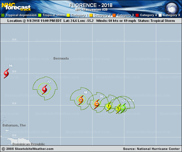
Copy of official data Tropical Storm Florence Discussion Number 39 NWS National Hurricane Center Miami FL AL062018 1100 PM AST Sat Sep 08 2018 Satellite images indicate that the cloud pattern has continued to gradually become better organized with an eye feature trying to form. An average of all of the Dvorak satellite intensity estimates tonight suggest that Florence is not a hurricane yet, but is close to being one. The initial intensity is kept at 60 kt in this advisory. The recent ASCAT data showed less winds than previously observed by the NOAA plane when the cloud pattern was less organized. There is a band of convection trying to wrap around a possible eye feature, and that is an indication that Florence has continued to recover from the hostile shear environment, which brought the hurricane from Category 4 to a tropical storm in a matter of a day or so. The presence of developing upper-level outflow is a good indication that the shear has decreased, and with the presence of a warm ocean ahead, strengthening is anticipated. As indicated by my predecessor, the official forecast continues to call for a period of rapid intensification in about 12-24 hours, and Florence is expected to reach major hurricane intensity between 36-48 hours with additional strengthening thereafter. Florence is forecast to be an intense hurricane on days 3 through 5 as it moves across the warm waters of the southwestern Atlantic Ocean between the Bahamas and Bermuda, and then as it heads toward the southeast United States coast. Florence is still trapped within very light steering currents, and is slowly moving toward the west or 270 degrees at 5 kt. All indications are that this is about to change, as a strong ridge of high pressure builds to the north of the hurricane. This forecast flow pattern predicted by the global models will force Florence on a general west-northwest to northwest track with an increase in forward speed. The NHC forecast is basically on top of the previous one, and is in the middle of the narrow guidance envelope mainly for the next 3 to 4 days. By the end of the forecast period, when the hurricane is approaching the U.S. coast, the guidance envelope is wider and becomes bounded by the northernmost GFS and the southernmost HCCA and the FSSE ensembles. One thing all models coincide at the longer range is with the collapsing of the steering currents, resulting in a significant reduction of the forward speed of the hurricane. Key Messages: 1. Florence is forecast to be a dangerous major hurricane near the southeast U.S. coast by late next week, and the risk of direct impacts continues to increase. However, given the uncertainty in track and intensity forecasts at those time ranges, it's too soon to determine the exact timing, location, and magnitude of those impacts. 2. Interests along the U.S. East Coast, particularly from north Florida through North Carolina, should closely monitor the progress of Florence, ensure they have their hurricane plan in place, and follow any advice given by local officials. 3. Large swells affecting Bermuda and portions of the U.S. East Coast will continue into next week. These swells will result in life-threatening surf and rip currents. FORECAST POSITIONS AND MAX WINDS INIT 09/0300Z 24.6N 55.2W 60 KT 70 MPH 12H 09/1200Z 24.5N 55.9W 70 KT 80 MPH 24H 10/0000Z 24.8N 57.4W 80 KT 90 MPH 36H 10/1200Z 25.2N 59.3W 100 KT 115 MPH 48H 11/0000Z 25.8N 61.8W 110 KT 125 MPH 72H 12/0000Z 27.5N 67.5W 125 KT 145 MPH 96H 13/0000Z 30.0N 73.5W 125 KT 145 MPH 120H 14/0000Z 33.8N 77.8W 115 KT 130 MPH $$ Forecaster Avila |