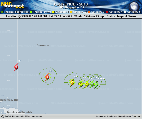
Official Discussion issued by the National Hurricane Center
Florence (AL062018) DATA RELEASED: 9/8/2018 5:00:00 AM UTC
|
Copy of official data Tropical Storm Florence Discussion Number 36 NWS National Hurricane Center Miami FL AL062018 500 AM AST Sat Sep 08 2018 Although Florence remains a sheared tropical cyclone, satellite imagery during the past 6 h also indicates that the shear has started to abate somewhat, which has allowed the dense cirrus canopy to build back over the previously exposed low-level circulation center. Furthermore, deep convection with overshooting cloud tops near -80C and an abundance of lightning activity have developed very close to the center. Based on these data along with Dvorak intensity estimates of T3.5/55 kt from TAFB and SAB, the initial intensity has been raised to 55 kt. The initial motion estimate is 265/8 kt. The mid-latitude flow across CONUS and the northern Atlantic is forecast to flatten out and become more zonal over the next 48 h or so, resulting in the development of a narrow east-west oriented ridge along 35/36N latitude. This large-scale feature is expected to steer Florence in a general westward direction during that time. By days 3-5, however, the flow across the central and western U.S. is forecast to buckle and become more meridional as a deep mid-/upper-level trough over the northeast Pacific pushes inland over the western U.S., causing downstream ridging over the northeastern U.S. and northwestern Atlantic. The global models agree on this general change in the synoptic-scale flow pattern, but they differ noticeably on where a downstream mid-/upper-level high pressure cell takes up residence over the Atlantic either to the northwest or northeast of Bermuda. The farther west/east the high develops will determine how far west/east Florence will eventually move and possibly affect the U.S. east coast beyond the 5-day forecast period. The new official forecast track is close to the previous advisory track through 48 h, and then was nudged a little to the left or west of the previous track, which is close to the consensus model TVCN and is north of the corrected-consensus models FSSE and HCCA since the bulk of the NHC model guidance lies north of those latter two models. The upper-level environment is expected to improve to significantly during the next 12 h and beyond with the current 20 kt of southwesterly shear forecast to give way to shear of less than 10 kt. By 72 h and beyond, light shear from the southeast and east along with the development of strong upper-level outflow jets to the north of Florence is expected to create an environment that favors significant and possibly even rapid strengthening. The new NHC intensity forecast has been increased over the previous advisory in anticipation of these very favorable dynamical conditions developing, and now shows Florence becoming a hurricane by Sunday and a major hurricane in 3 days, followed by additional strengthening over the very warm Atlantic waters of at least 29 deg C that are about 2 deg C above normal right now. The consensus models IVCN and HCCA were closely followed, which are a little below the FSSE model. Key Messages: 1. Regardless of Florence's eventual track, large swells are affecting Bermuda and will begin to affect portions of the U.S. East Coast this weekend, resulting in life-threatening surf and rip currents. 2. The risk of other direct impacts associated with Florence along the U.S. East Coast next week has increased. However, there is still very large uncertainty in model forecasts of Florence's track beyond day 5, making it too soon to determine the exact location, magnitude, and timing of these impacts. Interests near and along the U.S. East Coast should monitor the progress of Florence through the weekend and ensure they have their hurricane plans in place. FORECAST POSITIONS AND MAX WINDS INIT 08/0900Z 24.5N 54.2W 55 KT 65 MPH 12H 08/1800Z 24.6N 55.0W 60 KT 70 MPH 24H 09/0600Z 24.6N 56.0W 65 KT 75 MPH 36H 09/1800Z 24.6N 57.2W 75 KT 85 MPH 48H 10/0600Z 24.9N 59.0W 90 KT 105 MPH 72H 11/0600Z 26.0N 64.0W 105 KT 120 MPH 96H 12/0600Z 28.0N 70.2W 120 KT 140 MPH 120H 13/0600Z 30.9N 75.8W 125 KT 145 MPH $$ Forecaster Stewart |