Official Discussion issued by the National Hurricane Center
Florence (AL062018) DATA RELEASED: 9/7/2018 5:00:00 PM UTC
|
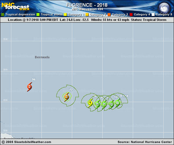
Copy of official data Tropical Storm Florence Discussion Number 34 NWS National Hurricane Center Miami FL AL062018 500 PM AST Fri Sep 07 2018 Little has changed with Florence's structure during the day. The low-level center is located on the southwestern side of the deep convection due to moderate to strong southwesterly shear, and satellite intensity estimates are essentially the same from this morning. Therefore, the estimated maximum winds remain 55 kt. NOAA is scheduled to conduct a research mission with the P-3 aircraft tomorrow, which should provide some useful wind data and give us a better handle on the cyclone's intensity. Vertical shear is still expected to gradually decrease over the next day or two, likely reaching values of 10 kt or less by 48 hours. During this period, Florence should become more vertically stacked, which would allow for some reintensification, possibly back to hurricane strength within 36-48 hours. After 48 hours, the shear is expected to remain generally low, and oceanic heat content values will increase significantly as Florence moves over the waters between Bermuda and the northern Leeward Islands. This is a classic recipe for a quick intensification trend, and Florence is expected to become a major hurricane by days 4 and 5. The generally skillful HCCA, Florida State Superensemble, and ICON intensity consensus are all near 110-115 kt by day 5, and because of this, no notable changes were required from the previous official intensity forecast. Florence has been moving south of due west (260 degrees) at 7 kt, located south of a low- to mid-level ridge. The cyclone is expected to continue moving generally westward for the next 48 hours while it remains sheared. As Florence begins to strengthen and become vertically stacked after 48 hours, it should begin to turn west-northwestward, steered by a deeper flow regime. By days 4 and 5, an exceptionally strong blocking ridge is forecast to develop between Bermuda and the Northeast U.S., keeping Florence on a west-northwestward trajectory with an increase in forward speed by the end of the forecast period. A slight southwestward adjustment was made to the NHC forecast to account for Florence's initial motion and a slight shift in the overall guidance envelope. For most of the forecast period, the official forecast is close to a blend of the GFS and ECMWF. Key Messages: 1. Regardless of Florence's eventual track, large swells are affecting Bermuda and will begin to affect portions of the U.S. East Coast this weekend, resulting in life-threatening surf and rip currents. 2. The risk of other direct impacts associated with Florence along the U.S. East Coast next week has increased. However, there is still very large uncertainty in model forecasts of Florence's track beyond day 5, making it too soon to determine the exact location, magnitude, and timing of these impacts. Interests near and along the U.S. East Coast should monitor the progress of Florence through the weekend and ensure they have their hurricane plans in place. FORECAST POSITIONS AND MAX WINDS INIT 07/2100Z 24.8N 52.5W 55 KT 65 MPH 12H 08/0600Z 24.6N 53.5W 55 KT 65 MPH 24H 08/1800Z 24.6N 54.7W 55 KT 65 MPH 36H 09/0600Z 24.6N 55.8W 60 KT 70 MPH 48H 09/1800Z 24.8N 57.0W 70 KT 80 MPH 72H 10/1800Z 25.8N 60.9W 90 KT 105 MPH 96H 11/1800Z 27.5N 67.0W 110 KT 125 MPH 120H 12/1800Z 30.5N 73.0W 115 KT 130 MPH $$ Forecaster Berg |