Official Discussion issued by the National Hurricane Center
Florence (AL062018) DATA RELEASED: 9/7/2018 5:00:00 AM UTC
|
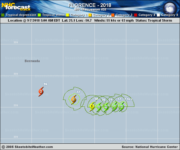
Copy of official data Tropical Storm Florence Discussion Number 32 NWS National Hurricane Center Miami FL AL062018 500 AM AST Fri Sep 07 2018 Florence's structure continues to be negatively affected by strong southwesterly shear. Cloud tops have generally warmed over the past 6 hours, and recent microwave data show that the low-level circulation center of Florence is displaced nearly 20 nmi to the southwest of the mid-level center. Satellite intensity estimates have decreased since last night, and now support an initial intensity of 55 kt. Based on GFS and ECMWF SHIPS diagnostic output, the southwesterly shear is near its peak now, and should gradually decrease over the next 24 to 36 h. All of the intensity guidance shows little change in intensity through that time. From 48 h onward, a low shear/warm SST environment should allow the tropical storm to re-strengthen. However, the extent and timing of the strengthening varies greatly from model to model, with the dynamical models generally showing more intensification, and sooner, than the statistical models. As has been the case for most of Florence's existence thus far, confidence in the intensity forecast, especially beyond 36 h, is low. The new official forecast is a little lower than the previous advisory for the first 48 h, but close to it after that, and lies between the more aggressive HCCA and less aggressive IVCN consensus aids. Nighttime Proxy-Vis and earlier microwave imagery indicate that Florence has turned westward, with an estimated initial motion of 275/6 kt. Most of the track guidance has shifted slightly toward the southwest, so the NHC track forecast has also been nudged in that direction. Over the next 3 days of the forecast, Florence should be steered generally westward, and then west-northwestward, by a mid-level ridge to its north. By days 4 and 5, a developing mid-latitude trough could create a weakness in this ridge and allow Florence to move more toward the northwest, but there is still considerable uncertainty in the global models and their ensembles regarding the strength of the ridge and if the aforementioned trough will have any notable impact on the track of Florence. The NHC forecast follows HCCA very closely, and is also near the middle of the large combined envelope of the GFS, UKMET, and ECMWF ensembles. Key Messages: 1. Regardless of Florence's eventual track, large swells will begin to affect Bermuda later today and portions of the U.S. East Coast this weekend, resulting in life-threatening surf and rip currents. 2. There is still very large uncertainty in Florence's track beyond day 5, and it is too soon to determine what, if any, other impacts Florence could have on the U.S. East Coast next week. 3. Since we are near the peak of hurricane season, this is a good time for everyone who lives in a hurricane-prone area to ensure they have their hurricane plan in place. FORECAST POSITIONS AND MAX WINDS INIT 07/0900Z 25.1N 50.7W 55 KT 65 MPH 12H 07/1800Z 25.1N 51.8W 55 KT 65 MPH 24H 08/0600Z 25.0N 53.2W 55 KT 65 MPH 36H 08/1800Z 25.0N 54.3W 60 KT 70 MPH 48H 09/0600Z 25.1N 55.4W 70 KT 80 MPH 72H 10/0600Z 26.2N 58.3W 95 KT 110 MPH 96H 11/0600Z 27.5N 63.5W 110 KT 125 MPH 120H 12/0600Z 30.0N 70.0W 110 KT 125 MPH $$ Forecaster Zelinsky |