Official Discussion issued by the National Hurricane Center
Florence (AL062018) DATA RELEASED: 9/6/2018 11:00:00 PM UTC
|
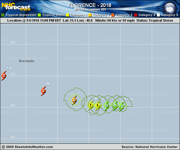
Copy of official data Tropical Storm Florence Discussion Number 31 NWS National Hurricane Center Miami FL AL062018 1100 PM AST Thu Sep 06 2018 Deep convection near the center of Florence has continued to decrease during the past several hours, and the overall cloud pattern remains elongated from southwest to northeast. The latest Dvorak estimates and a recent scatterometer pass suggest that Florence is no longer a hurricane, and the initial wind speed is set to 60 kt. Some further weakening is anticipated since the shear isn't forecast to change much in the short term. However, all of the global models show a significant reduction of shear during the next several days, especially later this weekend. In combination with waters warming to near 29C, these conditions should promote strengthening into a hurricane again in a day or two and a major hurricane by early next week. The intensity guidance is higher than the last cycle at long range, which is hard to argue with considering the large upper-level anticyclone forecast in the vicinity of Florence. The NHC intensity forecast follows the trend of the previous prediction, a bit elevated from the previous forecast at days 4 and 5, although still below the intensity guidance. A recent scatterometer pass indicates that Florence has slowed down and turned left, estimated at 290/6. A narrow ridge over the subtropical Atlantic Ocean should continue to turn the storm westward overnight, albeit traveling at a relatively slow pace due to the strength of the ridge. This ridge is forecast is strengthen at long range, steering Florence faster to the west-northwest over the western Atlantic Ocean. Except for the UKMET, most of the historically reliable guidance is in reasonable agreement on this scenario, which is a bit surprising given the recent trials and tribulations from the guidance suite. The models continue to shift westward at long range, however, owing to differences on the strength and position of that ridge, and the official NHC track forecast is moved in that direction. Key Messages: 1. Regardless of Florence's eventual track, large swells will begin to affect Bermuda on Friday and portions of the U.S. East Coast this weekend, resulting in life-threatening surf and rip currents. 2. There is still very large uncertainty in Florence's track beyond day 5, and it is too soon to determine what, if any, other impacts Florence could have on the U.S. East Coast next week. 3. Since we are near the peak of hurricane season, this is a good time for everyone who lives in a hurricane-prone area to ensure they have their hurricane plan in place. FORECAST POSITIONS AND MAX WINDS INIT 07/0300Z 25.1N 49.8W 60 KT 70 MPH 12H 07/1200Z 25.2N 50.8W 55 KT 65 MPH 24H 08/0000Z 25.2N 52.2W 60 KT 70 MPH 36H 08/1200Z 25.2N 53.6W 65 KT 75 MPH 48H 09/0000Z 25.3N 54.7W 75 KT 85 MPH 72H 10/0000Z 26.1N 57.3W 90 KT 105 MPH 96H 11/0000Z 27.6N 62.2W 105 KT 120 MPH 120H 12/0000Z 30.0N 68.5W 110 KT 125 MPH $$ Forecaster Blake |