Official Discussion issued by the National Hurricane Center
Florence (AL062018) DATA RELEASED: 9/2/2018 11:00:00 AM UTC
|
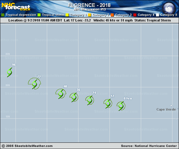
Copy of official data Tropical Storm Florence Discussion Number 13 NWS National Hurricane Center Miami FL AL062018 1100 AM AST Sun Sep 02 2018 Florence's convective cloud appearance has become rather disheveled this morning, with most of the deep convection sheared to the east and northeast of the now fully exposed but well-defined low-level circulation center. Both subjective and objective satellite intensity estimates have decreased, especially the objective ADT estimates from UW-CIMSS. Based on a blend of the available estimates, the intensity has been lowered to 45 kt. The initial motion is 285/16. Now that the system has weakened and become more vertically shallow, a more westward component of motion is expected throughout the forecast period. All but the GFS and HWRF models have picked up on this more westerly component of motion, and the ECMWF and UKMET models are now the southernmost models in the guidance suite. Since the ridge to the north is expected to remain intact and even build more westward over the next 5 days, the new NHC track forecast has been shifted southward and to the left of the previous advisory track, and lies close to a blend of the HCCA, FSSE, and TCVN track consensus models. Analyses from UW-CIMSS indicate that westerly to southwesterly vertical wind shear of 15-20 kt is undercutting the otherwise favorable upper-level outflow pattern noted in water vapor imagery and by the GFS- and ECMWF-based SHIPS model, which show the shear to be less than 10 kt. GOES-16 mid-level water vapor imagery also reveals that Florence is ingesting considerable dry air in the western and southern quadrants, with the dry mid-level air having penetrated into the inner-core region. Since the vertical shear is expected to get a little worse over the next 3-4 days while the cyclone is moving over SSTs near 26 deg C, little change in strength is forecast through 96 h. By 120 h, however, Florence is forecast to move over warmer waters with SSTs exceeding 28 deg C and also into a weaker shear environment, which should allow for some re-strengthening to occur. The new NHC intensity forecast is a little lower than the one in the previous advisory, and closely follows the consensus model IVCN, through 96 h, and then is a little above the guidance at 120 h. FORECAST POSITIONS AND MAX WINDS INIT 02/1500Z 17.0N 33.2W 45 KT 50 MPH 12H 03/0000Z 17.4N 35.3W 45 KT 50 MPH 24H 03/1200Z 17.9N 38.2W 45 KT 50 MPH 36H 04/0000Z 18.4N 40.7W 45 KT 50 MPH 48H 04/1200Z 18.9N 42.8W 45 KT 50 MPH 72H 05/1200Z 20.5N 47.0W 45 KT 50 MPH 96H 06/1200Z 22.4N 51.0W 45 KT 50 MPH 120H 07/1200Z 24.3N 54.3W 55 KT 65 MPH $$ Forecaster Stewart |