Official Discussion issued by the National Hurricane Center
Florence (AL062018) DATA RELEASED: 9/1/2018 5:00:00 PM UTC
|
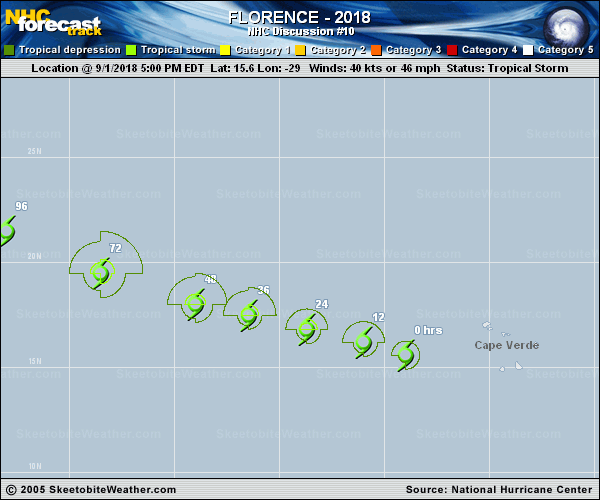
Copy of official data Tropical Storm Florence Discussion Number 10 NWS National Hurricane Center Miami FL AL062018 500 PM AST Sat Sep 01 2018 The cloud pattern has continued to improve with a circular area of convection near the center, and a cyclonically curved band surrounding the system. The upper-level outflow is fair in all quadrants. Although the cloud pattern is better organized, the Dvorak T-numbers have not changed, and only support 40 kt at this time. Florence has a couple of more days embedded within a low-shear environment which supports strengthening, but it is also currently heading toward marginal SSTs. By the time the cyclone reaches warmer waters again, the shear is forecast to be unfavorable. The best option at this time is to show only a very modest strengthening at the rate indicated by the intensity consensus aids. Florence has been moving toward the west-northwest or 285 degrees at 12 to 14 kt. No change in track is anticipated during the next 3 days while Florence is located to the south of the Atlantic subtropical ridge. After that time, Florence will reach a break in the ridge causing the cyclone to turn toward the northwest with a decrease in forward speed. The latter portion of the forecast is uncertain since the strength of the subtropical ridge to the north has been fluctuating from run to run in each model. At this time, the overall guidance has been shifting a little bit westward, suggesting a stronger ridge. On this basis, the NHC forecast was adjusted slightly in that direction at the end of the forecast period. FORECAST POSITIONS AND MAX WINDS INIT 01/2100Z 15.6N 29.0W 40 KT 45 MPH 12H 02/0600Z 16.2N 31.0W 45 KT 50 MPH 24H 02/1800Z 16.8N 33.7W 50 KT 60 MPH 36H 03/0600Z 17.5N 36.5W 55 KT 65 MPH 48H 03/1800Z 18.0N 39.0W 55 KT 65 MPH 72H 04/1800Z 19.5N 43.5W 55 KT 65 MPH 96H 05/1800Z 21.5N 48.0W 50 KT 60 MPH 120H 06/1800Z 23.5N 52.0W 50 KT 60 MPH $$ Forecaster Avila |