Official Discussion issued by the National Hurricane Center
Bret (AL032023) DATA RELEASED: 6/24/2023 3:00:00 AM UTC
|
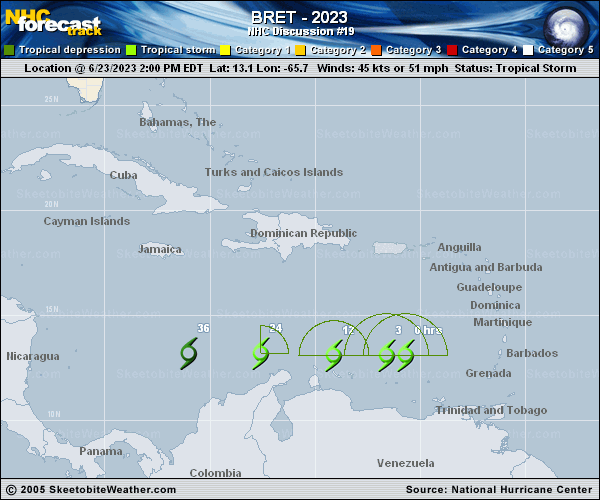
Copy of official data Tropical Storm Bret Discussion Number 19 NWS National Hurricane Center Miami FL AL032023 1100 PM AST Fri Jun 23 2023 Bret is currently comprised of an exposed swirl of low- to mid-level clouds with occasional puffs of convection to the northeast and east of the center. More widespread cloudiness and convection associated with the storm are occuring well to the east of the center over the southeastern Caribbean Sea. This poorly- organized structure is due to the effects of 25 kt of westerly vertical wind shear. Just-received reports from an Air Force Reserve Hurricane Hunter aircraft show a central pressure near 1005 mb, along with SFMR and flight-level winds supporting an initial intensity of 45 kt. Continued moderate to strong shear should cause Bret to weaken, and the global models forecast the system to degenerate into a trough or tropical wave between 24-36 h. The intensity forecast follows this guidance and shows the system dissipating after 24 h. The initial motion is 270/16 on the south side of a low- to mid-level ridge, and this general motion should continue until the system dissipates. The new NHC forecast track is similar to, but a little south of, the previous track. After dissipation, the remnants of Bret should move quickly westward and reach Central America sometime on Monday. FORECAST POSITIONS AND MAX WINDS INIT 24/0300Z 12.9N 68.1W 45 KT 50 MPH 12H 24/1200Z 13.0N 70.6W 40 KT 45 MPH 24H 25/0000Z 13.2N 74.1W 35 KT 40 MPH 36H 25/1200Z...DISSIPATED $$ Forecaster Beven |