Official Discussion issued by the National Hurricane Center
Chris (AL032018) DATA RELEASED: 7/8/2018 9:00:00 AM UTC
|
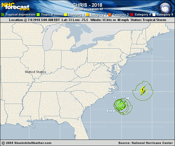
Copy of official data Tropical Storm Chris Discussion Number 7 NWS National Hurricane Center Miami FL AL032018 500 AM EDT Sun Jul 08 2018 An Air Force Reserve reconnaissance aircraft has been investigating the cyclone early this morning, and found flight-level winds of 45 kt at 925 mb and believable SFMR surface winds of around 34 kt in the southeast quadrant. On this basis, the system has been designated as Tropical Storm Chris, the 3rd named storm of the 2018 Atlantic season. Although the winds associated with the tropical storm have increased a little, the overall organization of Chris has not changed much over the past few hours. The low-level center is still exposed to the north of a broken band of deep convection and the cyclone lacks an inner-core. Chris is located over very warm SSTs and will remain so for the next several days. While the broad nature of the cyclone's circulation and some moderate shear will likely limit the intensification rate over the next day or so, all of the intensity guidance indicates that Chris will become a hurricane within about 72-h. By day 4, the intensity forecast is more uncertain, and depends strongly on the timing of Chris crossing the Gulf Stream, since the cyclone is expected to continue to intensify as long as it remains over warm waters. Once extratropical transition begins, weakening should occur as the wind field broadens. The new intensity forecast is close to HCCA and IVCN through day 3, and slightly lower beyond that, closer to the previous forecast. The track guidance has once again made a large shift with the latest forecast cycle. While Chris is generally expected to continue to meander off the coast of the Carolinas for the next couple of days before accelerating to the northeast ahead of a deep-layer trough approaching from the northwest, the timing of this acceleration is highly uncertain. Nearly all of the dynamical models have now shifted to the south and west of their previous forecasts throughout most of the forecast period. The NHC track forecast has been adjusted in that direction, but now lies on the eastern side of the guidance envelope, and shows a faster motion than most of the models. Given the large run-to-run inconsistency of the guidance over the past 24 hours, I would prefer to wait to make a more significant change to the forecast until a more clear pattern emerges. The Air Force reconnaissance plane also measured winds to gale-force about 20 miles off the coast of North Carolina. These winds are associated with the tight pressure gradient between Chris and high pressure over the northeastern U.S. See products issued by the National Weather Service forecast offices for more details. FORECAST POSITIONS AND MAX WINDS INIT 08/0900Z 33.0N 75.5W 35 KT 40 MPH 12H 08/1800Z 33.0N 75.4W 40 KT 45 MPH 24H 09/0600Z 32.8N 75.3W 45 KT 50 MPH 36H 09/1800Z 32.6N 75.1W 55 KT 65 MPH 48H 10/0600Z 32.7N 74.7W 60 KT 70 MPH 72H 11/0600Z 35.2N 71.5W 70 KT 80 MPH 96H 12/0600Z 41.5N 64.0W 70 KT 80 MPH 120H 13/0600Z 49.0N 54.5W 55 KT 65 MPH...POST-TROP/EXTRATROP $$ Forecaster Zelinsky |