Official Discussion issued by the National Hurricane Center
(AL032018) DATA RELEASED: 7/12/2018 11:00:00 AM UTC
|
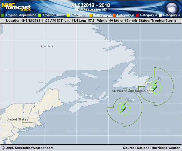
Copy of official data Post-Tropical Cyclone Chris Discussion Number 24 NWS National Hurricane Center Miami FL AL032018 1100 AM AST Thu Jul 12 2018 Extratropical transition has been ongoing for the past few hours, with the rain shield continuing to expand and clouds tops warming in the northwestern semicircle. In addition, surface observations close to the center now show a sharp temperature gradient of almost 20 deg F across the center, which is indicative of the cyclone having merged with a cold frontal system. As a result, Chris has become a post-tropical/extratropical cyclone. The intensity of 60 kt is based on continuity with the previous advisory and earlier ASCAT scatterometer passes. Gradual weakening is forecast by all of the intensity model guidance, but the cyclone is still expected to remain a gale area through 72 hours. Chris has made a slight westward jog, but the latest model guidance insists that the cyclone will start moving back toward the northeast or 045 degrees at 30-31 kt. Post-tropical cyclone Chris is forecast to remain embedded within the fast mid-latitude westerly flow on the east side of a broad, deep-layer trough moving eastward over the northeastern United States and southeastern Canada for the next 48 hours or so. By 72 hours, the cyclone is expected to slow down and begin moving northward as it interacts with a larger mid-latitude upper-level low. The NHC model guidance remains tightly packed, so only minor adjustments to the previous advisory track were required, and mainly in just the first 12 hours. On the forecast track, the center of Chris is expected to pass over or near the Avalon Peninsula of southeastern Newfoundland around 2100-0000 UTC this afternoon and evening. This is the last public advisory issued by the National Hurricane Center on this system. Additional information on this system can be found in High Seas Forecasts issued by the National Weather Service, under AWIPS header NFDHSFAT1, WMO header FZNT01 KWBC, and available on the Web at https://ocean.weather.gov/shtml/NFDHSFAT1.shtml. Other information on Post-Tropical Cyclone Chris can be found in products issued by Environment Canada/Canadian Hurricane Centre on the internet at weather.gc.ca/hurricane/. FORECAST POSITIONS AND MAX WINDS INIT 12/1500Z 44.4N 57.7W 60 KT 70 MPH...POST-TROPICAL 12H 13/0000Z 47.7N 52.8W 55 KT 65 MPH...POST-TROP/EXTRATROP 24H 13/1200Z 50.7N 44.7W 45 KT 50 MPH...POST-TROP/EXTRATROP 36H 14/0000Z 53.5N 35.0W 40 KT 45 MPH...POST-TROP/EXTRATROP 48H 14/1200Z 56.5N 26.5W 35 KT 40 MPH...POST-TROP/EXTRATROP 72H 15/1200Z 61.6N 18.9W 35 KT 40 MPH...POST-TROP/EXTRATROP 96H 16/1200Z...DISSIPATED $$ Forecaster Stewart |