Official Discussion issued by the National Hurricane Center
Beryl (AL022018) DATA RELEASED: 7/7/2018 5:00:00 AM UTC
|
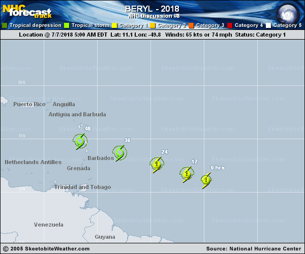
Copy of official data Hurricane Beryl Discussion Number 8 NWS National Hurricane Center Miami FL AL022018 500 AM AST Sat Jul 07 2018 Although there has been no recent microwave imagery to help examine the inner-core structure of Beryl, the small tropical cyclone appears to have lost some organization since yesterday afternoon. Shortwave GOES-16 infrared imagery suggests that the center is near the northwestern portion of the small convective mass. Dvorak data T-numbers from both TAFB and SAB have dropped to T3.5 while CI numbers support keeping Beryl a 65-kt hurricane, but this could be generous. The hurricane seems to have finally gained some latitude and the initial motion estimate is west-northwest or 285/12 kt. Beryl is located to the south of a strong mid-level ridge that is anchored over the west-central Atlantic. This should keep the cyclone on a general west-northwestward heading with some increase in forward speed over the next few days. The track models did not change much this cycle and only slight adjustments were made to the previous NHC forecast. The official forecast is once again along the southern side of the guidance envelope, in best agreement with the UKMET and FSSE models. Beryl is expected to remain in a light vertical wind shear environment today, but an increase in westerly shear is expected on Sunday, and the shear is forecast to become quite strong as Beryl moves over the eastern Caribbean early next week. As a result, the new NHC intensity forecast calls for little change in strength during the next 24-36 h, but predicts steady weakening after that time. The updated intensity forecast is lower than the previous advisory due to the lower initial intensity and less bullish intensity guidance. The new NHC forecast also shows Beryl degenerating into an open trough in 3 to 4 days, which is in good agreement within the global models that all predict this to occur while the system moves across the eastern Caribbean. Regardless of whether the system has a closed circulation, it is likely to continue producing strong gusty winds and locally heavy rainfall over portions of the Greater Antilles next week. Key Messages: 1. Beryl is forecast to be near hurricane strength when it approaches the Lesser Antilles Sunday night or Monday, and the chance of some islands receiving direct impacts from wind and rainfall continue to increase. Hurricane and tropical storm watches are in effect for some of the countries in the Lesser Antilles, and additional watches could be required for other islands today. 2. Due to its very small size, there is greater-than-usual uncertainty in the analysis of Beryl's current intensity, and confidence in the official intensity forecast is also lower than normal. Rapid changes in intensity, both up and down, that are difficult to predict are possible during the next couple of days. FORECAST POSITIONS AND MAX WINDS INIT 07/0900Z 11.1N 49.8W 65 KT 75 MPH 12H 07/1800Z 11.7N 51.6W 65 KT 75 MPH 24H 08/0600Z 12.6N 54.4W 65 KT 75 MPH 36H 08/1800Z 13.7N 57.9W 60 KT 70 MPH 48H 09/0600Z 14.8N 61.6W 55 KT 65 MPH 72H 10/0600Z 17.2N 70.0W 45 KT 50 MPH 96H 11/0600Z...DISSIPATED $$ Forecaster Brown |