Official Discussion issued by the National Hurricane Center
ALEX (AL012016) DATA RELEASED: 1/13/2016 11:00:00 PM UTC
|
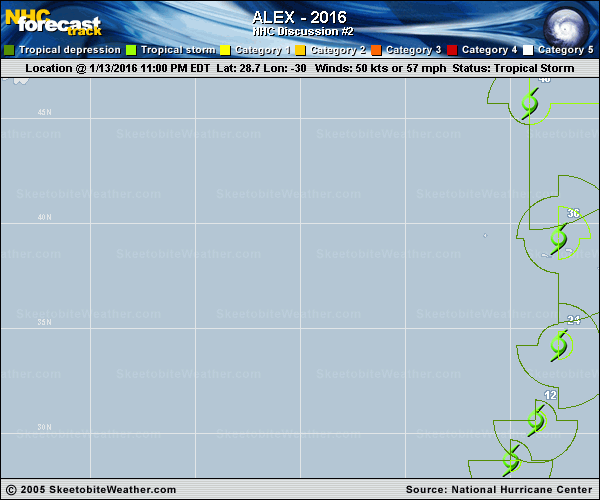
Copy of official data SUBTROPICAL STORM ALEX DISCUSSION NUMBER 2 NWS NATIONAL HURRICANE CENTER MIAMI FL AL012016 1100 PM AST WED JAN 13 2016 Evening satellite imagery indicates that Alex continues to generate a complex of curved convective bands, and an eye has been trying to form inside the innermost band. Satellite intensity estimates are 55-65 kt from TAFB and 55 kt from SAB. In addition, recent ASCAT-B data showed winds of 50 kt about 30 n mi southeast of the center. Based on these data, the initial intensity is increased to 50 kt, and this could be a little conservative. Even though Alex has strengthened, the system is still underneath an upper-level trough, and it has not yet developed the upper-level outflow characteristic of a tropical cyclone. Alex has continued to turn toward the left and the initial motion is now 035/15. The cyclone is expected to turn northward during the next 12-24 hours due to the influence of a large extratropical low over the northwestern Atlantic. Alex is expected to turn more northwestward on the northeast side of this low after 48 hours, with this motion continuing until the two system merge between 72-96 hours. The new forecast track is very similar to the previous track, and it calls for Alex to pass near or over the Azores in about 36 hours. The subtropical storm is expected to move over colder sea surface temperatures during the next day or so, and little change in strength is expected during that time. After that, the cyclone should gradually intensify during and after extratropical transition, which should be complete at about the time the cyclone passes near or through the Azores. The new intensity forecast is stronger than the previous forecast and shows Alex as a storm-force cyclone for the next 72 hours. Gale and storm force winds, as well as locally heavy rains, are likely to affect portions of the Azores beginning late Thursday or early Friday. FORECAST POSITIONS AND MAX WINDS INIT 14/0300Z 28.7N 30.0W 50 KT 60 MPH 12H 14/1200Z 30.6N 28.8W 50 KT 60 MPH 24H 15/0000Z 34.2N 27.7W 50 KT 60 MPH 36H 15/1200Z 39.3N 27.7W 55 KT 65 MPH...POST-TROP/EXTRATROP 48H 16/0000Z 45.7N 29.1W 55 KT 65 MPH...POST-TROP/EXTRATROP 72H 17/0000Z 58.0N 37.0W 60 KT 70 MPH...POST-TROP/EXTRATROP 96H 18/0000Z...MERGED WITH EXTRATROPICAL LOW $$ Forecaster Beven |