Official Discussion issued by the National Hurricane Center
Lorenzo (AL122025) DATA RELEASED: 10/15/2025 3:00:00 AM UTC
|
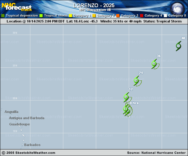
Copy of official data Tropical Storm Lorenzo Discussion Number 8 NWS National Hurricane Center Miami FL AL122025 1100 PM AST Tue Oct 14 2025 Lorenzo continues to struggle this evening, with convective organization. However, satellite images depict that there has been a recent burst of convection near the center of the system, although these bursts have been intermittent throughout the day. Subjective and objective satellite intensity estimates range from 35 to 45 kt. Given the convection has only just recently returned over the center, the initial intensity will be held at 35 kt for this advisory. The storm is moving north-northwestward at an estimated motion of 345/10 kt. A turn to the north is expected overnight as the system rounds the western edge of a subtropical ridge, followed by an accelerated northeastward motion throughout the rest of the forecast period as the system becomes engulfed in the flow of an approaching trough from the west. The NHC track forecast is similar to the previous, just a little faster and lies between the simple and corrected consensus aids. The drier air and wind shear have continued to take their toll on Lorenzo, with convection remaining disorganized. As Lorenzo begins to accelerate the system is anticipated to struggle to produce organized convection and maintain a closed circulation, eventually opening into a trough. The latest NHC intensity forecast moved up dissipation to 48 h, although most global models show Lorenzo opening into a trough and dissipating even sooner. FORECAST POSITIONS AND MAX WINDS INIT 15/0300Z 19.6N 45.6W 35 KT 40 MPH 12H 15/1200Z 21.3N 44.9W 35 KT 40 MPH 24H 16/0000Z 24.0N 42.6W 35 KT 40 MPH 36H 16/1200Z 26.9N 38.9W 35 KT 40 MPH 48H 17/0000Z...DISSIPATED $$ Forecaster Kelly |