Official Discussion issued by the National Hurricane Center
Debby (AL042024) DATA RELEASED: 8/4/2024 3:00:00 AM UTC
|
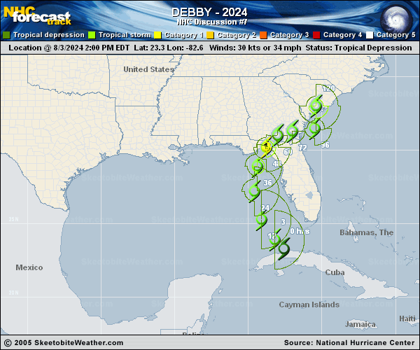
Copy of official data Tropical Storm Debby Discussion Number 7 NWS National Hurricane Center Miami FL AL042024 1100 PM EDT Sat Aug 03 2024 NOAA and Air Force Reserve Hurricane Hunter aircraft have been investigating Debby during the past few hours and have found that the winds have increased slightly and the central pressure has fallen. The NOAA P-3 plane reported SFMR measurements of 35-40 kt east of the center over the Straits of Florida, and dropsonde data indicate that the central pressure has fallen to 1003 mb. The initial intensity is therefore raised to 40 kt. Debby is gradually turning toward the right and slowing down, and the initial motion is northwestward, or 320/12 kt. A large mid- to upper-level trough over the eastern United States has created a break in the subtropical ridge, which will cause Debby to move northward over the eastern Gulf of Mexico and approach the Florida Big Bend region over the next day or two. The track guidance is in good agreement during this period, and the NHC track has only been shifted slightly east to account for a slight relocation of the initial position based on the aircraft data. After 2-3 days, the steering currents around Debby collapse, and the cyclone is expected to creep northeastward at less than 5 kt across northern Florida to near the coasts of Georgia and South Carolina by day 5. While there is model disagreement on exactly where Debby will end up on day 5, there is high confidence that the storm will not be moving very fast, and this slow motion will have major implications for the associated hazards, particularly heavy rainfall and flooding. Low vertical shear and very warm waters (as warm as 32 degrees Celsius within Apalachee Bay) are likely to support additional strengthening while Debby approaches the Florida Big Bend. The intensity guidance has increased a bit on this cycle. Most of the regional hurricane models are showing Debby reaching hurricane strength before it reaches the coast, while the statistical-dynamical SHIPS and LGEM models have increased to the 75-80-kt range. In addition, the Rapid Intensification indices are showing a 1-in-3 chance of a 45-kt increase in intensity over the next 36 hours. Based on these model data, the NHC intensity forecast has been increased to 75 kt in 36 hours, just before the center of Debby is expected to reach the coast. Weakening is anticipated after landfall, but Debby's intensity on days 3 through 5 is highly uncertain and is dependent on whether the center moves over the Atlantic waters and for how long. Key Messages: 1. Heavy rainfall will likely result in considerable flash and urban flooding across portions of Florida and the coastal areas of the Southeast through Thursday. Significant river flooding is also expected. 2. Hurricane conditions are expected on Monday along portions of the Florida Big Bend region where a Hurricane Warning is in effect, with tropical storm conditions beginning late Sunday. Tropical storm conditions are expected through Monday farther south within the Tropical Storm Warning along Florida's west coast, including the Tampa Bay area and the Lower Florida Keys. 3. There is a danger of life-threatening storm surge inundation along portions of the Gulf coast of Florida from Aripeka to Indian Pass. Life-threatening storm surge is possible south of Aripeka to Bonita Beach, including Tampa Bay and Charlotte Harbor. 4. Impacts from storm surge, strong winds, and heavy rains are possible elsewhere in Florida and along the southeast coast of the United States from Georgia to North Carolina through the middle of next week, and interests in those areas should continue to monitor the progress of this system. Additional watches and warnings will likely be required on Sunday. FORECAST POSITIONS AND MAX WINDS INIT 04/0300Z 24.4N 83.6W 40 KT 45 MPH 12H 04/1200Z 25.9N 84.2W 50 KT 60 MPH 24H 05/0000Z 27.8N 84.3W 60 KT 70 MPH 36H 05/1200Z 29.3N 84.0W 75 KT 85 MPH 48H 06/0000Z 30.3N 83.3W 55 KT 65 MPH...INLAND 60H 06/1200Z 31.0N 82.4W 40 KT 45 MPH...INLAND 72H 07/0000Z 31.2N 81.5W 40 KT 45 MPH...INLAND 96H 08/0000Z 31.6N 80.2W 45 KT 50 MPH...OVER WATER 120H 09/0000Z 33.0N 80.5W 40 KT 45 MPH...INLAND $$ Forecaster Berg |