Official Discussion issued by the National Hurricane Center
Four (AL042024) DATA RELEASED: 8/3/2024 9:00:00 AM UTC
|
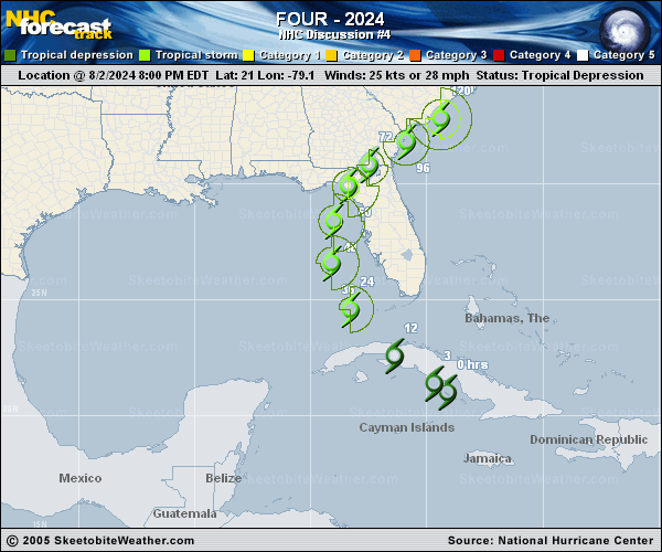
Copy of official data Tropical Depression Four Discussion Number 4 NWS National Hurricane Center Miami FL AL042024 500 AM EDT Sat Aug 03 2024 Small bursts of deep convection have continued near the estimated center of the depression, with some skeletal convective bands over the outer portions of the circulation. Earlier scatterometer data revealed the strongest winds were occurring to the south and east of the center, offshore of the southern coast of Cuba. The overall organization of the tropical cyclone has changed little overnight, and the initial intensity is held at 25 kt based on the earlier scatterometer winds and recent Dvorak estimates from TAFB and SAB. The estimated motion of the depression is still west-northwestward at about 14 kt. The influence of an upper-level trough over the eastern United States should cause the cyclone to turn northwestward and then northward this weekend as it moves toward a break in the subtropical ridge. This motion will bring the system across western Cuba this morning, into the eastern Gulf of Mexico later today, and toward the Florida Big Bend region on Sunday and Sunday night. There is reasonably good confidence in this portion of the track forecast, and only slight westward adjustments were made to the NHC prediction based on the latest track consensus aids. After landfall, weakening steering currents should cause the cyclone to slow down while it moves northeastward over parts of northern Florida and Georgia. Thereafter, the track forecast becomes highly uncertain as it is unclear whether the system will accelerate northeastward ahead of an upper trough (GFS) or get left behind and meander over the southeastern U.S. or near the coast (ECMWF). After the system crosses Cuba and emerges over the eastern Gulf of Mexico, the environmental and oceanic conditions appear favorable for intensification. The latest NHC forecast shows the cyclone becoming a tropical storm by tonight, with additional strengthening expected while it moves across deep warm waters in a weak shear environment. The regional hurricane models and statistical guidance continue to indicate some potential for the system to reach hurricane strength before it makes landfall in the Florida Big Bend region. Although the latest NHC forecast does not explicitly show the cyclone becoming a hurricane, note that additional strengthening could occur between 48-60 h. Weakening is forecast after landfall while the system moves over the southeastern United States. Beyond day 3, the intensity forecast remains quite uncertain and highly dependent on whether the center stays inland or emerges off the Atlantic coast. Key Messages: 1. Heavy rainfall may result in locally considerable flash and urban flooding across portions of Florida and the coastal areas of the Southeast U.S. this weekend through Wednesday. Isolated river flooding will also be possible. 2. A Hurricane Watch has been issued for portions of west-central Florida and the Big Bend region, where hurricane conditions are possible late Sunday. Tropical storm conditions are expected farther south along FloridaG��s west coast, including the Tampa Bay area, and across the Dry Tortugas where Tropical Storm Warnings are in effect. 3. There is a possibility of life-threatening inundation from storm surge along portions of the west coast of Florida from Bonita Beach to Aucilla River, including Tampa Bay and Charlotte Harbor, where a Storm Surge Watch is in effect. 4. Impacts from storm surge, strong winds, and heavy rains are possible elsewhere in Florida and along the southeast coast of the United States from Georgia to North Carolina through the middle of next week, and interests in those areas should continue to monitor the progress of this system. Additional watches and warnings will likely be required later today. FORECAST POSITIONS AND MAX WINDS INIT 03/0900Z 22.0N 80.7W 25 KT 30 MPH 12H 03/1800Z 23.4N 82.6W 30 KT 35 MPH 24H 04/0600Z 25.3N 83.9W 40 KT 45 MPH 36H 04/1800Z 27.5N 84.3W 50 KT 60 MPH 48H 05/0600Z 29.1N 83.9W 60 KT 70 MPH 60H 05/1800Z 30.4N 83.1W 45 KT 50 MPH...INLAND 72H 06/0600Z 31.2N 82.2W 35 KT 40 MPH...INLAND 96H 07/0600Z 32.0N 80.5W 45 KT 50 MPH...OVER WATER 120H 08/0600Z 33.0N 79.0W 55 KT 65 MPH $$ Forecaster Reinhart |