Official Discussion issued by the National Hurricane Center
Debby (AL042024) DATA RELEASED: 8/8/2024 3:00:00 PM UTC
|
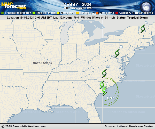
Copy of official data Tropical Storm Debby Discussion Number 25 NWS National Hurricane Center Miami FL AL042024 1100 AM EDT Thu Aug 08 2024 Debby continues to move farther inland with the center now located over northern South Carolina. Surface observations and radar data indicate that the strongest winds are likely occurring near the coast and just offshore of southern North Carolina. The highest sustained winds during the past couple of hours from reliable surface observation sites are near 30 kt with higher gusts. Based on the decreasing observed wind speeds, the initial intensity is lowered to 35 kt for this advisory. By far, the most significant threat with Debby continues to be flash flooding from heavy rainfall. Debby is starting to accelerate toward the north-northwest, with the current motion estimated at 345/9-kt. A ridge that is currently strengthening over the western Atlantic will cause Debby to accelerate northward, moving across central North Carolina this evening. Then, a deep-layer trough will approach the Great Lakes region on Friday, which will cause Debby to accelerate northeastward over the Mid-Atlantic and Northeast U.S. Friday and Friday night and then over Atlantic Canada on Saturday. There are only minor changes to the track forecast, hedging toward the latest consensus models. Debby should continue to weaken as it moves farther inland, and most of the models indicate that the winds near the coast should decrease a bit more later today. Debby is expected to weaken to a tropical depression by this afternoon or evening. Model phase space diagrams show that Debby should complete transition to an extratropical cyclone in about 24 to 30 h. The current satellite imagery shows that Debby is already starting to interact with the jet stream, which extends toward the east-northeast over the North Atlantic. Debby is now expected to complete extratropical transition in about 24 h as the cyclone merges with a cold front while over the mid-Atlantic states. Beyond Friday, models show a post-tropical Debby becoming extremely elongated along the cold front, which will eventually lead to dissipation. The new NHC forecast has Debby dissipating Sunday morning, but that could occur sooner. Key Messages: 1. Heavy rainfall across portions of the Carolinas is expected to persist through today along with areas of considerable flooding. Heavy rainfall will also result in considerable to locally catastrophic flooding impacts across portions of the Mid-Atlantic States and Northeast through Saturday morning. 2. Tropical storm conditions will continue for several more hours in the Tropical Storm Warning area along the coast of northeastern South Carolina and portions of North Carolina. 3. Coastal flooding due to storm surge is likely to continue along portions of the North Carolina coastline for several more hours. FORECAST POSITIONS AND MAX WINDS INIT 08/1500Z 34.5N 79.9W 35 KT 40 MPH...INLAND 12H 09/0000Z 35.8N 79.9W 30 KT 35 MPH...INLAND 24H 09/1200Z 38.7N 78.8W 30 KT 35 MPH...POST-TROP/EXTRATROP 36H 10/0000Z 42.8N 75.0W 30 KT 35 MPH...POST-TROP/EXTRATROP 48H 10/1200Z 47.0N 69.3W 30 KT 35 MPH...POST-TROP/EXTRATROP 60H 11/0000Z 50.7N 61.9W 30 KT 35 MPH...POST-TROP/EXTRATROP 72H 11/1200Z...DISSIPATED $$ Forecaster Hagen/Cangialosi |