Official Discussion issued by the National Hurricane Center
Debby (AL042024) DATA RELEASED: 8/8/2024 3:00:00 AM UTC
|
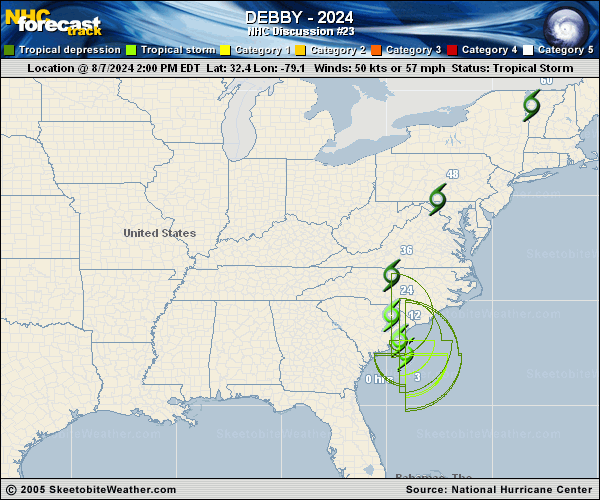
Copy of official data Tropical Storm Debby Discussion Number 23 NWS National Hurricane Center Miami FL AL042024 1100 PM EDT Wed Aug 07 2024 Satellite imagery and surface observations indicate that Debby has a large central area of light and variable winds, with bands of deep convection well removed from the center in both the northern and southern semicircles. The initial intensity is held at 50 kt for this advisory, with these winds likely confined to the area of stronger convection to the southeast of the center. The central pressure based on surface observations is near 994 mb. Debby has been drifting just west of due north for the past several hours with an initial motion of 345/3. This has brought the center near the South Carolina coast, and it is expected to move inland during the next few hours. A continued slow north-northwestward motion is expected for the next 24 h, with the center crossing eastern South Carolina moving into North Carolina. After that, the cyclone should recurve to the north and northeast on the east side of a mid-latitude trough near the Great Lakes. The latest track guidance has shifted a little to the west of the previous guidance, and the new forecast track is also shifted a little westward. Little change in strength is expected before the center moves inland. After that, Debby is expected to weaken, with the system dropping below tropical-storm strength after 24 h. As Debby crosses through the mid-Atlantic States, the cyclone is expected to merge with a frontal system and become an extratropical low by 60 h. However, it is important to note that none of these changes will diminish the threat of heavy rainfall and flooding across portions of the Carolinas, Mid-Atlantic, and northeastern United States during the next few days. Key Messages: 1. Heavy rainfall across portions of the Carolinas is expected to persist through Thursday along with areas of considerable flooding. Expected heavy rainfall will also result in considerable flooding impacts across portions of the Mid-Atlantic States and Northeast through Saturday morning. 2. Tropical storm conditions will affect portions of the South Carolina and North Carolina coast through Thursday. Tropical storm warnings and watches are in effect for portions of that area. 3. Coastal flooding due to storm surge is likely along portions of the South Carolina and North Carolina coastline through Thursday. FORECAST POSITIONS AND MAX WINDS INIT 08/0300Z 32.9N 79.5W 50 KT 60 MPH 12H 08/1200Z 33.7N 79.8W 45 KT 50 MPH...INLAND 24H 09/0000Z 35.3N 80.0W 35 KT 40 MPH...INLAND 36H 09/1200Z 38.1N 79.0W 30 KT 35 MPH...INLAND 48H 10/0000Z 42.1N 75.6W 30 KT 35 MPH...INLAND 60H 10/1200Z 46.3N 70.5W 30 KT 35 MPH...POST-TROP/EXTRATROP 72H 11/0000Z 49.0N 64.0W 30 KT 35 MPH...POST-TROP/EXTRATROP 96H 12/0000Z...DISSIPATED $$ Forecaster Beven |