Official Discussion issued by the National Hurricane Center
Debby (AL042024) DATA RELEASED: 8/7/2024 9:00:00 PM UTC
|
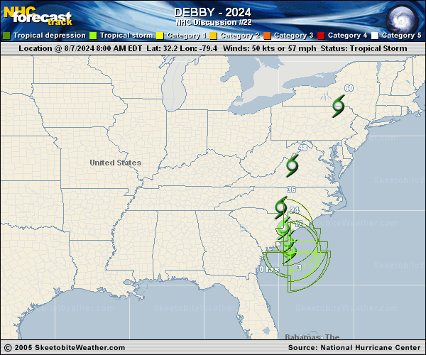
Copy of official data Tropical Storm Debby Discussion Number 22 NWS National Hurricane Center Miami FL AL042024 Issued by the NWS Weather Prediction Center College Park MD 500 PM EDT Wed Aug 07 2024 Debby is producing small, broken bands of convection around its center this afternoon. The storm continues to meander around NOAA buoy 41004, and data from that station indicate the central pressure remains around 995 mb. The Air Force Hurricane Hunters reported peak SFMR winds of 47 kt within convection to the northeast of the center during their last pass through the storm a few hours ago. Based on these data and the earlier flight-level winds, the initial intensity is held at 50 kt. Although the storm is moving over warm waters, it lacks an inner core and has a large radius of maximum wind. Therefore, only modest strengthening is forecast during the next 12 h while the system approaches South Carolina, in best agreement with some of the statistical guidance. Once inland, Debby is expected to quickly lose tropical characteristics and weaken. The interaction of Debby with the upper trough will lead to a baroclinic transition as the low merges with a frontal zone and becomes extratropical. The NHC forecast shows this occurring by Friday. However, it is important to note that these changes do not diminish the threat of heavy rainfall and flooding across portions of the Carolinas, Mid-Atlantic, and northeastern United States during the next few days. The long-term motion of Debby is a north-northeastward drift within weak steering currents between two subtropical high pressure areas. However, more recent fixes suggest the system may be turning northward as expected, with a ridge beginning to build to the east of Debby over the western Atlantic. Thus, a north-northwestward to northward motion is expected through tonight while Debby approaches the coast of South Carolina. After landfall, Debby will become caught in southerly to southwesterly flow ahead of a mid-latitude trough near the Great Lakes region. This will cause the storm to accelerate north-northeastward to northeastward on Friday and into the weekend. With the guidance in good agreement on this scenario, little change was made to the updated NHC track forecast. Key Messages: 1. Heavy rainfall across portions of the Carolinas is expected to persist through Thursday along with areas of considerable flooding. Expected heavy rainfall will also result in considerable flooding impacts across portions of the Mid-Atlantic States and Northeast through Saturday morning. 2. Tropical storm conditions will affect portions of the South Carolina and North Carolina coast through Thursday. Tropical storm warnings and watches are in effect for portions of that area. 3. Coastal flooding due to storm surge is likely along portions of the South Carolina and North Carolina coastline through Thursday. FORECAST POSITIONS AND MAX WINDS INIT 07/2100Z 32.5N 79.1W 50 KT 60 MPH 12H 08/0600Z 33.1N 79.4W 55 KT 65 MPH...NEAR THE COAST 24H 08/1800Z 34.3N 79.8W 40 KT 45 MPH...INLAND 36H 09/0600Z 36.2N 79.8W 30 KT 35 MPH...POST-TROPICAL 48H 09/1800Z 39.8N 77.6W 30 KT 35 MPH...POST-TROP/EXTRATROP 60H 10/0600Z 44.3N 73.1W 30 KT 35 MPH...POST-TROP/EXTRATROP 72H 10/1800Z 48.8N 67.3W 30 KT 35 MPH...POST-TROP/EXTRATROP 96H 11/1800Z 53.0N 56.0W 30 KT 35 MPH...POST-TROP/EXTRATROP 120H 12/1800Z...DISSIPATED $$ Forecaster Reinhart |