Official Discussion issued by the National Hurricane Center
Debby (AL042024) DATA RELEASED: 8/7/2024 3:00:00 PM UTC
|
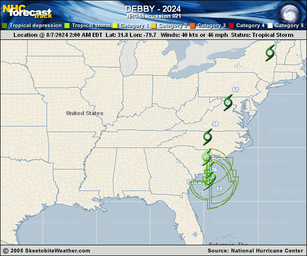
Copy of official data Tropical Storm Debby Discussion Number 21 NWS National Hurricane Center Miami FL AL042024 1100 AM EDT Wed Aug 07 2024 Observations from an Air Force Hurricane Hunter aircraft indicate surface winds to near 50 kt in an area located over 100 n mi southeast of the center. Most of Debby's deep convection is occurring in bands well to the northeast and southeast of the center, with limited shower and thunderstorm activity near/over the center. The advisory intensity is increased to 50 kt based on the aircraft data. The cyclone has been moving slowly northeastward and the initial motion estimate is 040/4 kt. Debby is currently situated between two subtropical high pressure centers and remains within relatively weak steering currents. Later today and tonight, the ridge to the east of Debby should build slightly and cause the system to move generally northward and make landfall in 12 to 24 hours. The steering flow ahead of a mid-latitude trough near the Great Lakes is likely to cause Debby to accelerate north-northeastward to northeastward over the eastern U.S. during the next few days. The NHC track forecast is similar to the previous one and is in good agreement with the corrected consensus guidance. Given that the strongest winds are occurring well to southeast of the center, Debby lacks a well-defined inner core, which indicates that significant re-intensification is not likely. However, since the system lies over warm water this could allow for some limited strengthening before landfall and this is reflected in the official forecast. The official forecast remains at the high end of the model intensity guidance. Debby should merge with a frontal zone and become an extratropical cyclone over the northeastern U.S. in a couple of days. Key Messages: 1. Heavy rainfall across portions of the Carolinas is expected to persist through Thursday along with areas of considerable flooding. Expected heavy rainfall will also result in considerable flooding impacts across portions of the Mid-Atlantic States and Northeast through Saturday morning. 2. Tropical storm conditions will affect portions of the South Carolina and North Carolina coast through Thursday. Tropical storm warnings and watches are in effect for portions of that area. 3. Coastal flooding due to storm surge is likely along portions of the South Carolina and North Carolina coastline through Thursday. FORECAST POSITIONS AND MAX WINDS INIT 07/1500Z 32.3N 79.2W 50 KT 60 MPH 12H 08/0000Z 32.9N 79.4W 55 KT 65 MPH 24H 08/1200Z 33.8N 79.7W 45 KT 50 MPH...INLAND 36H 09/0000Z 35.2N 79.9W 30 KT 35 MPH...INLAND 48H 09/1200Z 38.0N 79.1W 30 KT 35 MPH...INLAND 60H 10/0000Z 42.0N 76.0W 30 KT 35 MPH...POST-TROP/EXTRATROP 72H 10/1200Z 46.5N 71.0W 30 KT 35 MPH...POST-TROP/EXTRATROP 96H 11/1200Z 52.5N 60.0W 30 KT 35 MPH...POST-TROP/EXTRATROP 120H 12/1200Z 54.0N 52.0W 30 KT 35 MPH...POST-TROP/EXTRATROP $$ Forecaster Pasch |