Official Discussion issued by the National Hurricane Center
Humberto (AL082025) DATA RELEASED: 9/25/2025 3:00:00 AM UTC
|
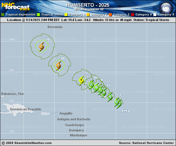
Copy of official data Tropical Storm Humberto Discussion Number 2 NWS National Hurricane Center Miami FL AL082025 1100 PM AST Wed Sep 24 2025 The cloud pattern of Humberto has changed little in organization over the past several hours. Some rudimentary convective banding features are evident but the cold cloud tops are rather fragmented at this time. Upper-level outflow is being restricted over the western portion of the circulation, at least partially due to the outflow from disturbance 94L located near Puerto Rico. The current intensity estimate is set at 40 kt in agreement with a recently received scatterometer pass. The storm center is not yet very well-defined so the initial motion is a rather uncertain 300/10 kt. Over the next few days, Humberto should be steered generally west-northwestward to northwestward on the southwestern side of a subtropical mid-level high pressure area. The steering scenario for the tropical cyclone will likely become more complicated in 2-3 days due to the interaction with the developing system 94L to the west. The official forecast track is quite similar to the previous one, and roughly in the middle of the guidance. However, due to the likely complications in the evolution of the steering flow, there is lower than normal confidence in this track forecast. Global models suggest that there will be some relaxation in westerly vertical wind shear over Humberto in the coming days. This, along with very warm ocean waters and a moist mid-level air mass, should lead to strengthening. The system will probably become a hurricane in a couple of days, and then strengthen into a major hurricane. The official intensity forecast is in reasonable agreement with the simple and corrected model consensus, including the latest FSU Superensemble forecast. FORECAST POSITIONS AND MAX WINDS INIT 25/0300Z 20.7N 55.8W 40 KT 45 MPH 12H 25/1200Z 21.4N 56.7W 45 KT 50 MPH 24H 26/0000Z 21.9N 57.3W 50 KT 60 MPH 36H 26/1200Z 22.4N 57.9W 55 KT 65 MPH 48H 27/0000Z 22.9N 58.8W 60 KT 70 MPH 60H 27/1200Z 23.4N 60.1W 70 KT 80 MPH 72H 28/0000Z 24.0N 62.0W 85 KT 100 MPH 96H 29/0000Z 26.3N 66.0W 100 KT 115 MPH 120H 30/0000Z 30.1N 68.9W 100 KT 115 MPH $$ Forecaster Pasch/Blake |