Official Discussion issued by the National Hurricane Center
Jerry (AL102025) DATA RELEASED: 10/11/2025 3:00:00 PM UTC
|
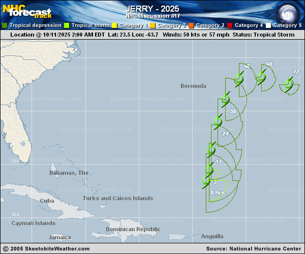
Copy of official data Tropical Storm Jerry Discussion Number 17 NWS National Hurricane Center Miami FL AL102025 1100 AM AST Sat Oct 11 2025 There are strong indications this morning that Jerry may no longer have a well-defined center of circulation. Although there is obvious mid-level rotation in a small area of deep convection, low cloud lines in visible satellite imagery suggest the system may have degenerated into a surface trough of low pressure, which is echoed by global model fields. We will continue advisories at the moment, pending some ASCAT data which should provide some additional clarity on the system's structure. Advisories could be discontinued at any time if new data shows that Jerry has opened up into a trough. Satellite intensity estimates are no higher than about 45 kt, so the current intensity is reduced to that value. The European, UKMET, and Canadian models show Jerry's circulation remaining stretched out and weakening while beginning to merge with a frontal boundary located to its north near 30N in about 24 hours. Even the GFS, which keeps Jerry separate from the frontal boundary, shows the peak winds decreasing. The new NHC forecast now shows Jerry becoming post-tropical by 48 hours and dissipating 72 hours, but both of these transitions could occur much earlier. Although the center is not well defined, the entire system is moving northward (005 degrees) at 14 kt. A turn toward the northeast is expected on Sunday, followed by an eastward motion on Monday as Jerry merges with a front and becomes embedded in mid-latitude westerly flow. The new track forecast is generally just an update of the previous prediction. FORECAST POSITIONS AND MAX WINDS INIT 11/1500Z 25.8N 63.2W 45 KT 50 MPH 12H 12/0000Z 28.0N 62.8W 45 KT 50 MPH 24H 12/1200Z 30.3N 62.0W 40 KT 45 MPH 36H 13/0000Z 32.0N 60.8W 35 KT 40 MPH 48H 13/1200Z 32.6N 59.0W 35 KT 40 MPH...POST-TROPICAL 60H 14/0000Z 32.0N 56.6W 35 KT 40 MPH...POST-TROP/EXTRATROP 72H 14/1200Z...DISSIPATED $$ Forecaster Berg |